Edit Operation Data
What is it?
This interface allows users to modify HRU level scheduled management operation data (.ops). These management operations are non-recurring activities that, once started, remains in effect throughout the simulation process. This is useful in initializing conservation measures after the simulation has started.How to use it:
Subbasin number, land use, soil, slope and HRU number of the HRU currently being edited are displayed on the top.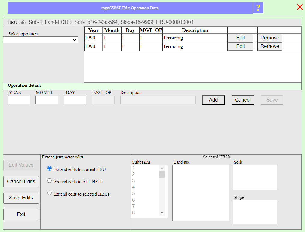
Edit operation parameters
To start an operation, select an operation from the dropdown list under 'Select operatio'. Next, enter the date the operation started, and click 'Add'. Once added, click 'Edit' button on the operation table on the right to enter/modify operation parameters.Parameter description:
Terracing
TERR_P: USLE practice factor adjusted for terraces (0 to 1).
TERR_CN: Initial SCS curve number II value (20 to 100).
TERR_SL: Average slope length (m) (0 to 100).
Tile draains
DRAIN_D: Depth to the subsurface drain (mm) (0 to 6000).
DRAIN_T: Time to drain to field capacity (hr) (0 to 100).
DRAIN_G: Drain tile lag time (hr) (0 to 100).
DRAIN_IDEP: Depth to impermeable layer (mm) (0 to 6000).
Contouring
CONT_CN: Initial SCS curve number II value (20 to 100).
CONT_P: Contour USLE P factor (0 to 1).
Filter strip
VFSI: Flag for the simulation of filter strips; 0: inactive, 1: active.
VFSRATIO: Ratio of field area to filter strip area (ha2/ha2)(0 to 300).
VFSCON: Fraction of the HRU that drains to the most concentrated 10% of the filter strip area (ha2/ha2)(0.25 to 0.75).
VFSCH: Fraction of the flow within the most concentrated 10% of the filter strip which is fully channelized (0 to 100).
Strip cropping
STRIP_N: Manning's N value for overland flow in strip cropped fields (0.001 to 0.5).
STRIP_CN: SCS curve number II value for strip cropped fields (20 to 100).
STRIP_C: USLE cropping factor for strip cropped fields (0 to 1).
STRIP_P: USLE practice factor for strip cropped fields (0 to 1).
Fire
Fire_CN: Post fire SCS curve number II value (20 to 100).
Grassed waterway
GWATI: Flag for the simulation of grass waterways; 0: inactive, 1: active.
GWATN: Manning's N value for overland flow (0.001 to 0.5).
GWATL: Length of grassed waterway (km) (0 to 10000).
GWATW: Average width of grassed waterway (m) (0 to 1000).
GWATD: Depth of grassed waterway channel from top of bank to bottom (m) (0 to 10).
GWATS: Average slope of grassed waterway channel (0 to 1).
GWATSPCON: Linear parameter for calculating sediment in grassed waterways (0 to 1).
Plant parameter
CROPNO_UPD: Updated crop number (0 to 150).
HI_UPD: Updated harvest index (0 to 1).
LAIMX_UPD: Updated leaf area index (0 to 10).
Residue management
SO_RES_FLAG: Conservation practice code; 0: inactive, 1: active.
SO_RES: Residue (kg/ha) (0 to 5000).
Generic conservation practice
RO_BMP_FLAG: Code to turn on/off user BMP, 0: inactive, 1: active.
RO_BMP_SED: Sediment removal by BMP (%) (0 to 100).
RO_BMP_PP: Particulate (organic) phosphorus removal by BMP (%) (0 to 100).
RO_BMP_SP: Soluble phosphorus removal by BMP (%) (0 to 100).
RO_BMP_PN: Particulate (organic) nitrogen removal by BMP (%) (0 to 100).
RO_BMP_SN: Soluble nitrogen removal by BMP (%) (0 to 100).
Applying the changes
To apply the changes to current HRU only, check 'Extend edits to current HRU' under 'Extend parameter edits'.To apply the changes to all HRUs, check 'Extend edits to ALL HRUs' under 'Extend parameter edits'.
To apply the changes to selected HRUs, including the current one, check 'Extend edits to selected HRUs' under 'Extend parameter edits' select the subbasins from the list on the right. Next, select the landuses, soils and slopes to apply the changes.
Click 'Save Edits' and close the interface.
Don't forget to click 'Save Edits' butoon on the 'mgnSWAT Edit SWAT Data' interface.