
|
|||||||
|
|
|||||||
| ❮❮ |
|
|
|
|
|
|
❯❯ |
|
|
|||||||
INTRODUCING M4W-StormNETA Global Digital Twin Modeling Technology for Urban Water SystemsLeveraging the ongoing global digital transformation, especially the global spatial data revolution, generative CAD, and open AI, we introduce MAGNET 4 WATER (MW4) - StormNET, a next-generation global digital twin modeling technology for integrated urban water and green infrastructure systems . The urban water systems simulated include:
UNIQUE CAPABILITIESM4W-StormNET is unique in that it is cloud-powered, data-enabled, AI assisted, and realtime interactive. Dynamic Digital TwinThe platform generates instantly a “real life-like” 3D, dynamic digital twin based on user inputs and simulation results that vary over time in response to time-dependent climatic stresses (e.g., rain, temperature) linked from national or international data storehouses or from user supplied sensor data.Realtime ModelingM4W-StormNET allows interactive modeling, visualization, analysis, reporting, and publication. Users can zoom in anywhere in the world to quickly build using big data a model, analysis, and visualization that can be further refined with user’s own data. The platform also allows users to publish instantly data and model results to the world, or cyber-enabled environmental observatories, to showcase their capabilities and achievements - in high impact 3D visualizations, animations, and intelligent reports.Platform as a ServiceThe M4W-StormNET platform is delivered as a service system, combining IaaS (infrastructure as a service), PaaS (platform as a service), SaaS (software as a service), and DaaS (data as a service) - accessible anywhere, anytime on demand through an internet browser.Algorithms Comes to DataUnlike traditional software, the M4W-StormNET technology is directly built on the data networks, eliminating the bottlenecks associated with modeling with big data that are becoming increasingly immovable. These bottlenecks include computational bottlenecks, as well as human operational bottlenecks, human cognitive bottlenecks, and network communication bottlenecks.GLOBAL DATABASE SYSTEMAll modeling and design tools are live-linked to a comprehensive, systematic global database system consisting of raw, processed, and simulated data from an international network of (hundreds of) data services. This includes data services provided by Hydrosimulatics, and by a number of federal or national agencies, including: US Geological Survey (USGS), US National Weather Service (NWS), National Oceanic and Atmospheric Administration (NOAA), US Department of Agriculture (USDA), Federal Emergency Management Agency (FEMA), and more. Climate Data
Land Data
Soil Data
Water / Hydrology Data
MULTIPLE USER COMMUNITIESThe realtime modeling technology creates a new, instant channel for research, education, consulting, management, simultaneously benefiting multiple segments of the environmental communities and communities related to, influenced by, and serving (or served by) the environmental communities, including students, educators, researchers, professors, planners and managers, and policy/decision makers. More specifically, the platform benefits:
REALTIME DYNAMIC DATA FUSIONThe software seamlessly and dynamically merges heterogeneous and distributed geo-spatial information into a single map - joining and viewing together separate data sets that share all or part of the same space or literally “fusing” maps together. The result of this combination is a new data set that identifies complex spatial relationships that evolve over time. Computational SteeringThe new technology allows users’ thought processes to progress naturally and intuitively with the correct information visualized, analyzed, overlaid, and compared at the instant it is required, providing a real sense of continuous exploration.Being able to watch flow and transport processes evolve over time and visualize instantaneously the complex interrelationships among hydrological and environmental variables sparks pivotal insights, giving rise to an intuitive grasp of the hydrogeological and chemical processes that can't be readily obtained otherwise. Realtime DiscoveryThe seamless model integration, visual interactivity, and real-time processing and communication capability makes it possible for scientists and engineers to focus on critical conceptual issues and to quickly and iteratively examine modeling approximations and hypotheses, identify dominant processes, assess data worth and model uncertainty, calibrate and validate the numerical representation, and experiment in real time with design and management options.NUMERICAL ENGINEThe M4W-StormNET platform makes use of the EPA’s Storm Water Management Model (SWMM) – a program widely used by the international water resources community. The underlying SWMM modeling engine solves the full Saint Venant equation for unsteady flow using the dynamic wave routing method, allow modeling diverse flow scenarios or regimes, including pressurized or unpressurized flow, backwater, surcharging, and reverse flow, as well as surface ponding, street flooding, and flood inundation, in branched and/or looped networks in response to event-based, individual storm events or long term continuous stresses and boundary conditions. ARTIFICIAL INTELLIGENCEThe world is witnessing a revolution in customer service and support, fueled by a number of emerging technologies such as predictive analytics, voice and face recognition, and, most importantly, Artificial Intelligence (AI). AI enables hyper-personalization, proactive issue resolution, and interactive, convenient self-service experiences. It empowers users to independently find solutions to their questions and issues with convenience and efficiency; it provides immediate answers without waiting in line or holding for a service representative. Instant Personalized SupportM4W-StormNET leverages AI to enhance the experience and satisfaction using (and learning with) the platform. Users can ask questions, within context, at anytime, from anywhere, 24/7, receiving a response instantly that is reliable, accurate, consistent, systematic, comprehensive, unbiased, and patient.The types of questions that can be asked include those related to:
Comprehensive “Knowledge Databases”The AI Assistant is trained with a wealth of existing documentation and information, including:
Realtime Situational HelpIn addition to AI-based assistances, a comprehensive suite of “traditional” user reference material is situationally embedded inside the M4W-StormNET modeling platform interfaces and submenus. Real-time help buttons provide instant access to sub-pages explaining how to use different options or features; tutorials guide users through both focused “modules” or integrated system design. The Realtime Help Pages are continuously improving and include not only technical reference material, but also links to related scientific material (e.g., typical parameter values, numerical / computational aspects, etc.).URBAN WATER SYSTEMS MODELINGM4W-StormNET provides realtime tools for data driven decision making, process based modeling, and for planning, analysis, and design related to stormwater runoff, coupled stormwater/sanitary systems and combined sewer overflows, and other drainage systems. It can be used for evaluating gray infrastructure control strategies for stormwater, such as pipes and storm drains, and creating cost-effective green-gray hybrid stormwater control systems; reducing runoff through infiltration and retention, and help to reduce discharges that impair waterbodies. Stormnet supports local, state, national, and international sustainable development goals in relation to clean water and creation of resilient urban water infrastructures. Typical Applications include: designing and sizing of drainage system components for flood control; sizing detention facilities and their appurtenances for flood control and water quality protection; mapping flood plains of natural channel systems— The modeling engine SWMM 5 is a FEMA-approved model for National Flood Insurance Program studies; designing control strategies for minimizing combined sewer overflows; evaluating the impact of inflow and infiltration on sanitary sewer overflows; generating nonpoint source pollutant loadings for waste load allocation; controlling site runoff using green infrastructure practices as low LID controls; evaluating the effectiveness of best management practices and low impact development for reducing wet weather pollutant loadings. 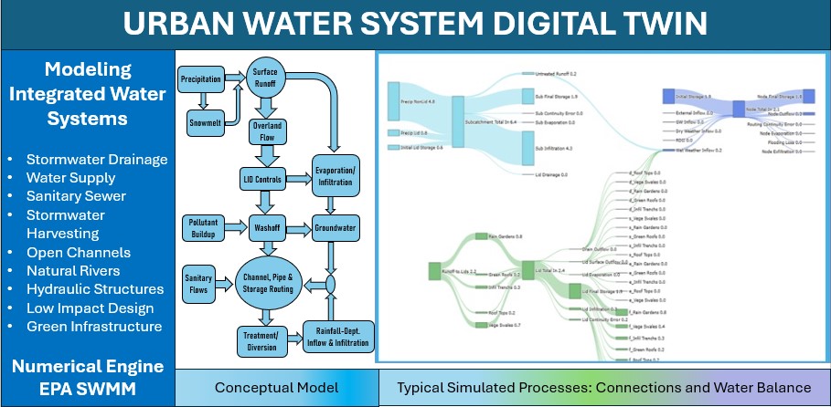
Figure 1: Introducing M4W-StormNET - a next-generation Digital Twin modeling technology for urban water systems. Stormnet enables high-fidelity simulation and visualization of urban water distribution and water drainage systems, green infrastructure and low-impact design, and flood inundation and river system dynamics. 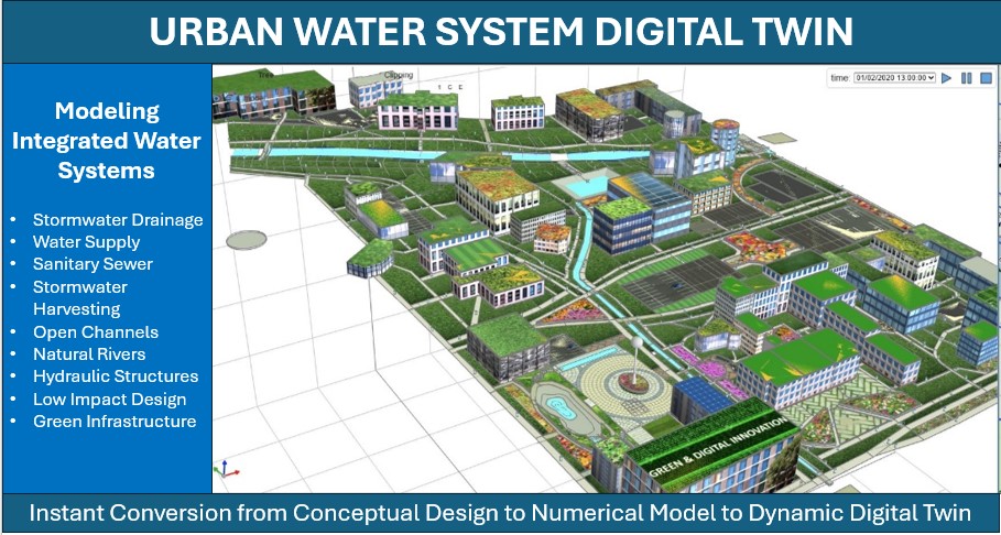
Figure 2: Realistic representation of regular and irregular hydraulic structures (e.g., natural storage units, rain barrels, etc.) during simulation and integrated 3D visualization. 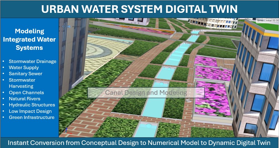
Figure 3: During the design process or after simulation, Stormnet enables system-level visualization of the built and natural environment, including the water system infrastructure and water quantity dynamics, i.e., water levels/storage in “links” (channels, pipes, etc.) and “nodes” (manholes, storage ponds, reservoirs) – for both above-ground and subsurface perspectives. 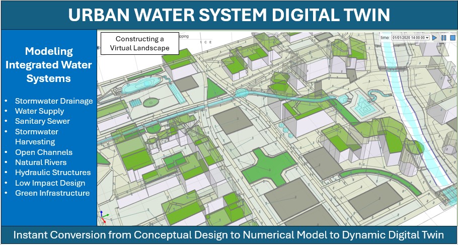
Figure 4: Users can visualize in 3D the complex subsurface water infrastructure network with 3D representations of buildings and other surface infrastructure. Stormnet provides full control and flexibility with respect to visualization of different components of the digital twin environment (i.e., layers or features can be turned “on” and “off”, user can control semi-transparency renderings, etc.). Users can even customize the building “textures” using the built-in texture database or upload textures/images of their own. |
|||||||