Cloud-based, Data-enabled, Realtime Interactive Global Groundwater Modeling
  • Home
    • Overview
    • MAGNET Modeling Features
  • MAGNET Network
    • Global Modeling Platform
    • Global Model Network
    • Global User Network
  • Library
    • Research Videos >
      • Real world heterogeneity
      • Random Field Representation
      • Effects of Spatial Heterogeneity
      • Effects of Temporal Variability
      • Effects of Interacting Heterogeneity
      • Effects of Multiscale Heterogeneity
      • Macridispersion Models
      • Monte Carlo Simulations
      • Transport in Complex Aquifers
      • Transport in Fractured Tills
    • Education Videos >
      • Regional Vertical Circulation
      • Seepage Under Dams
      • Aquifer Response to Pumping
      • Law of Refraction
      • FLow in Anisotropic Aquifers
      • Wellhead ​Delineation
      • Connection with Surface Water
      • Stream Aquifer Interaction
      • Artificial Recharge
      • Groundwater Contamination
      • Transport Processes
      • Groundwater Remediation
    • MAGNET USER REFERENCE >
      • Magnet Quick Tutorials
      • Magnet User Manual
    • IGW USER REFERENCE >
      • IGW2D References
      • IGW2D Example Problems
      • IGW3D User Manual
      • IGW3D Tutorials
      • IGW3D Reference Manual
    • IGW Verification >
      • Comparison with Analytical Solutions
      • Comparison with MODFLOW
      • Comparison with Field Observations
    • MGMT USER REFERENCE >
      • MGMT User Manual
      • MGMT Tutorials
    • MGMT Verification
    • Research Publications
    • Inquiry-based Learning
    • Real World Case Studies >
      • Gallery A
      • Gallery B
    • Published MAGNET NETWORK Models
  • Services
    • Advertising with Us
  • Support
    • MAGNET Account >
      • Sign Up
      • Edit Account
    • Frequently asked questions
    • MAGNET Discussion Forum
    • Live Chat
    • Terms & Privacy
    • Contact
    • Meet the Team
  • Career
    • Job Opening
Picture
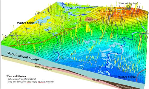
Mapping of aquifer extents (side elevations), groundwater head distribution, water well lithologies (vertical lines), surface water network (light blue lakes and dark blue streams/rivers), and important human infrastructure (highway and landfill location)
Picture
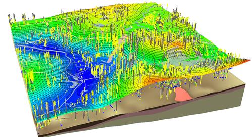
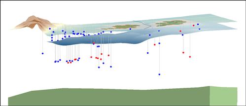
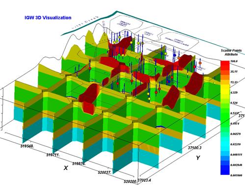
Groundwater head distribution, water well lithologies and water chemistry (vertical, colored lines), and surface water network (blue features).
Picture
Picture
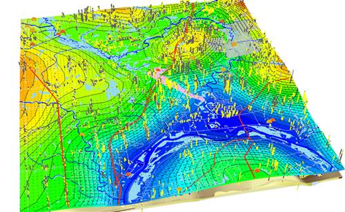
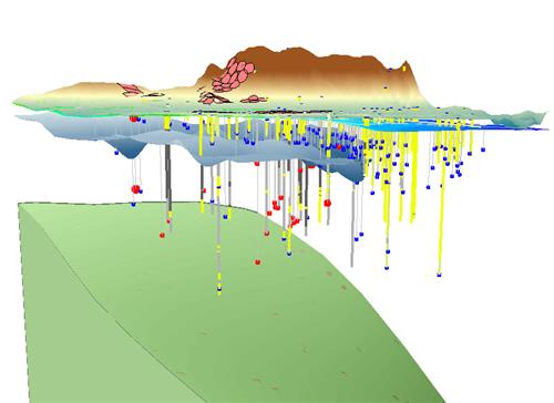
3D view into the subsurface, with a characterization of water well lithologies and water chemistry (vertical, colored lines), and the underlying geologic units.
Picture
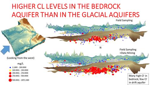
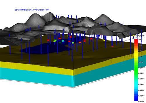
3D visualization of point measurements of dissolved chloride (Cl) collected from field sampling and historical data mining.
Picture
3D interpolation of dissolved chloride (Cl) concentrations in a county-wide aquifer system. Blue indicates low levels (<100 mg/L); red indicates high concentrations (>500 mg/L).
Picture
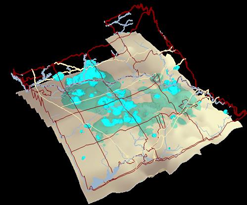
3D iso-surfaces of dissolved chloride concentrations of Cl=250 mg/L, in the unconsolidated sediments (light teal) and bedrock aquifer below (dark teal).
Picture
3D visualization of water quality below a landfill site.
Picture
Near-surface water quality near a wastewater spray irrigation field.
Picture
3D visualization of water quality at a contamination site.
Picture
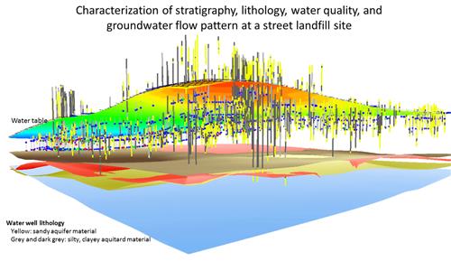
3D visualization of aquifer extents and groundwater quality measurements at a landfill contamination site.
Picture
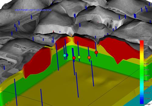
Close up of geology and groundwater water quality at a landfill contamination site.
Picture
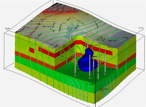
Groundwater head contours and a 3D iso-surface of water quality at contamination site.
  • Home
    • Overview
    • MAGNET Modeling Features
  • MAGNET Network
    • Global Modeling Platform
    • Global Model Network
    • Global User Network
  • Library
    • Research Videos >
      • Real world heterogeneity
      • Random Field Representation
      • Effects of Spatial Heterogeneity
      • Effects of Temporal Variability
      • Effects of Interacting Heterogeneity
      • Effects of Multiscale Heterogeneity
      • Macridispersion Models
      • Monte Carlo Simulations
      • Transport in Complex Aquifers
      • Transport in Fractured Tills
    • Education Videos >
      • Regional Vertical Circulation
      • Seepage Under Dams
      • Aquifer Response to Pumping
      • Law of Refraction
      • FLow in Anisotropic Aquifers
      • Wellhead ​Delineation
      • Connection with Surface Water
      • Stream Aquifer Interaction
      • Artificial Recharge
      • Groundwater Contamination
      • Transport Processes
      • Groundwater Remediation
    • MAGNET USER REFERENCE >
      • Magnet Quick Tutorials
      • Magnet User Manual
    • IGW USER REFERENCE >
      • IGW2D References
      • IGW2D Example Problems
      • IGW3D User Manual
      • IGW3D Tutorials
      • IGW3D Reference Manual
    • IGW Verification >
      • Comparison with Analytical Solutions
      • Comparison with MODFLOW
      • Comparison with Field Observations
    • MGMT USER REFERENCE >
      • MGMT User Manual
      • MGMT Tutorials
    • MGMT Verification
    • Research Publications
    • Inquiry-based Learning
    • Real World Case Studies >
      • Gallery A
      • Gallery B
    • Published MAGNET NETWORK Models
  • Services
    • Advertising with Us
  • Support
    • MAGNET Account >
      • Sign Up
      • Edit Account
    • Frequently asked questions
    • MAGNET Discussion Forum
    • Live Chat
    • Terms & Privacy
    • Contact
    • Meet the Team
  • Career
    • Job Opening