|
|
Numerical Flow Modeling I - Steady State
|
|
|
|
|
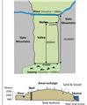
Water supply expansion and wetlands
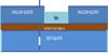
Intermediate - 2D flow modeling and water balance analysis. Background: The town of Hubertville is planning to expand its water supply by constructing a pumping well in an unconfined aquifer. The well is designed to pump constantly at a rate of 20,000 m3/day. Well construction was halted by the State Fish and Game Service who manage the Green Swamp Conservation area. The agency claimed that pumping would “significantly reduce” groundwater discharge to the swamp and damage a waterfowl habitat. The town claimed the fully penetrating river boundary to the north and the groundwater divide located near the center of the valley would prevent any change in flow to the swamp.
(Numerical Flow Modeling I - Steady State- 12)
|
|

|
|
Stream BioStation Wells
Intermediate - Analytical and numerical sub-problems. Scientists staying at a streamside biological station rely on a shallow, hand-dug water well to support their water needs during extended field visits. Recently, a large-scale horticulture center (greenhouse complex) was built nearby, requiring the extraction of large amounts of groundwater from the unconfined aquifer as the ecologically important stream is protected from any water abstractions. It is known that the stream and aquifer are well connected.
(Numerical Flow Modeling I - Steady State- 12)
|
|
|
|
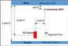
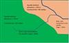
Wellhead Protection
Intermediate - Flow modeling; source water tracking; contaminant tracking. Background: A small community pumps groundwater from a confined sandstone aquifer for their drinking water supply (see figure). A recent monitoring study, however, shows that the aquifer is contaminated by a TCE plume near an industrial site upgradient of the community well. Although the well water is currently not contaminated, the citizens are concerned since groundwater is their exclusive source of water supply.
(Numerical Flow Modeling I - Steady State- 12)
|
|
|
|
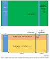
Lake Augmentation Well
Intermediate to Advanced. Multi-layer aquifer modeling; pumping and water balance analysis. Background: Little Lake is a shallow, highly utilized residential and recreational area, but has recently experienced falling water levels due to a relatively dry period. Residents and recreational users are concerned over related negative impacts, e.g., lower real estate values, poor boat navigation, etc. A lake augmentation well - which will pump groundwater from a deep aquifer (Aquifer B) directly into Little Lake - has been suggested as a way to restore lake levels. A thin aquitard layer exists between Aquifer B and the shallow aquifer (Aquifer A), but well production tests near the lake suggest a break in the layer exists at some unknown distance from the far side of the lake (see Figure 1). The high-flow, deeply incised Grand River is situated approximately 2000m from the lake / proposed augmentation well location.
(Numerical Flow Modeling I - Steady State- 12)
|
|
|
|
Streamflow Depletion
Intermediate to Advanced - Multi-layer aquifer modeling. Background: In almost all streams, there is movement of water between the underlying groundwater and the surface water body. Because of this interaction, depletions to streams due to pumping can occur either by wells that intercept water that otherwise would have flowed to the surface water bodies or by causing water to move from the streams to the well. Pumping-induced reductions in base flow are not instantaneous nor do they occur only to streams closest to the well. There can be significant interaction among surface water bodies and it can take years or decades for depletions to be fully realized.
(Numerical Flow Modeling I - Steady State- 12)
|
|
|
|
Critique of a Conceptual Groundwater Flow Model
Barron Lake, just East of Niles in Van Buren County, had significant water loss during the 2012 drought and conditions have not rebounded.The community has been exploring various options to augment the lake (raise the lake level) and one of them under active consideration involves pumping groundwater from a confined aquifer near the lake and adding the water pumped back to the lake. Critique the conceptual groundwater flow model proposed by a consultant that concluded, YES, the the augmentation project is feasible.
(Numerical Flow Modeling I - Steady State- 12)
|
|
|
|
The Two-faced Stream!
An interesting phenomenon, observed on a winter hydrogeology field trip: a sharp contrast in the flow condition between two stretches in a first order stream (creek) . One stretch was icy (mostly frozen), while another stretch from was not. Build a MAGNET model to explain it.
(Numerical Flow Modeling I - Steady State- 12)
|
|
|
|
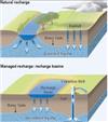
Artificial Recharge Using Spreading Basins
Artificial recharge of groundwater can often take place in spreading basins or stream channels. Build a MAGNET model and derive analytical solutions to characterize groundwater conditions and surface water-groundwater fluxes in this type of system.
(Numerical Flow Modeling I - Steady State- 12)
|
|

|
|
Biscayne Aquifer
The Biscayne aquifer is one of the most permeable aquifers in the world and consists principally of two layers: the Miami Limestone formation and the Fort Thomson formation. Calculate the shape of the phreatic surface and the flow between two fully penetrating canals 1 km apart using: MAGNET-IGW; MAGNET-MODFLOW; and an analytical approach. Compare the results and explain any differences.
(Numerical Flow Modeling I - Steady State- 12)
|
|
|
|
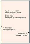
Agricultural Drains
Drains are sometimes used in agricultural regions with high water tables. Drains are thought to create a healthier environment for plant growth and to dry the soil so that it can be accessed by farm equipment throughout the crop production cycle. Build a MAGNET model to simulate the lowering of the water table at a farm as a result of two parallel agricultural drains constructed as trenches. Also solve the problem analytically and compare the results from the two different approaches.
(Numerical Flow Modeling I - Steady State- 12)
|
|

|
|
Flow through an Embankment
Flow passes through a stratified embankment from a lake on the upstream side to a lower water level on the downstream side. Develop a three layer MAGNET model and find the flow into the lower reservoir through the embankment and the distance from the upstream end at which layer 3 becomes unsaturated. Also solve the problem analytically and compare the results, and explain the difference, if any.
(Numerical Flow Modeling I - Steady State- 12)
|
|
|
|