-
Modeling Capabilities
-
Interactive Watershed Creation
-
Feature / Option FREE PREMIUM Load Watershed based on location and model scale ✔ ✔ Import DEM ✔ ✔ Burn stream network ✔ ✔ Stream threshold selection >1% of total grids User selected Select multiple outlets ✔ ✔ Import USGS gaugaging stations as outlets ✔ ✔ Import Soil Type ✔ ✔ Import Land Use ✔ ✔ Calculate Slope Percentages ✔ ✔ Merge smaller subbasins ✔ ✔ HRU creation method Multi options Multi options Multi options Number of HRUs No limitations No limitations No limitations Download topographic/HRU/soil/slope report ✔ ✔
-
-
Precipitation Modeling
-
Feature / Option FREE PREMIUM Historical Events (Observed Precip. Events) ✔ ✔ Future Events (Projected Precip. From Climate Models) ✔ ✔
-
-
Evapotranspiration Modeling
-
Feature / Option FREE PREMIUM Evaporation and Plant Transpiration (Evapotranspiration) Modeling - Based on Yemperature, Relative Humidity, Solar Radiation, and Wind Speed ✔ ✔
-
-
Infiltration Modeling
-
Feature / Option FREE PREMIUM Infiltration Modeling - Based on Curve Number Method or Green-Ampt Model ✔ ✔
-
-
Runoff and Stream Routing Modeling
-
Feature / Option FREE PREMIUM Surface runoff modeling ✔ ✔ Lateral (soil zone) runoff modeling ✔ ✔ Stream Routing using Manning's equatoin, and varaiable or Muskingum routing method ✔ ✔
-
-
Groundwater Modeling
-
Feature / Option FREE PREMIUM Shallow aquifer dynamics / water balance modeling -- ✔ Deep aquifer dynamics / water balance modeling -- ✔
-
-
Reservoir / Pond Modeling
-
Feature / Option FREE PREMIUM Reservoir operations modeling and pond strorage modeling ✔ ✔
-
-
Water Quality Modeling
-
Feature / Option FREE PREMIUM Nutrient cycling, pesticides, fertilizers, organic matter ✔ ✔
-
-
Interactively Edit SWAT input Parameters
-
Feature / Option FREE PREMIUM Edit watershed level input files ✔ ✔ Edit subbasin level input files ✔ ✔ Edit HRU level input files ✔ ✔
-
-
Add Input Sources
-
Feature / Option FREE PREMIUM Point sources (water quanity, water quality) -- ✔ Reservoirs -- ✔
-
-
Land use update
-
Feature / Option FREE PREMIUM Update landuse during simulation -- ✔
-
-
Model simulation
-
Feature / Option FREE PREMIUM Simulation length 5 years 30 year
-
-
Manual Model Calibration
-
Feature / Option FREE PREMIUM Single-parameter (one-at-a-time) Sensitivity Analyisis ✔ ✔ On-the-fly calculation and plotting of statistical indicators ✔ ✔
-
-
Automated Model Calibration
-
Feature / Option FREE PREMIUM Multi-parameter model optimization using the Non-Dominated Sorting Genetic Algorithm II (NSGA-II) ✔ ✔ Number of stations 1 Multiple Total years 10 years User defined Water quality calibration -- ✔ Poulation size 10 50 Number of generations 5 50
-
-
Consituent Load Estimator
-
Feature / Option FREE PREMIUM Embedded USGS LOAD ESTimator (LOADEST) program for esimating constiuent loads in streams and rivers ✔ ✔
-
-
Export to Groundwater Models
-
Feature / Option FREE PREMIUM Create river file for Groundwater modeling in IGW-NET Annual/cell size 50 Annual/transient/long-term Create recharge rasters compatiable as input to groundwater model in IGW-NET ✔ ✔
-
-
Model Import
-
Feature / Option FREE PREMIUM Load existing SWAT model from SwaNET ✔ ✔ Load existing SWAT model from elsewhere ✔ ✔ Load pre-processed SWAT models ✔ ✔
-
-
Server File Management
-
Feature / Option FREE PREMIUM Save SwaNET Model file to local computer ✔ ✔ Saved models on server 1 (last model) 1 (last model) Max. User Folder Size Limit - 100 MB Unlimited
-
-
Interactive Watershed Creation
-
Visualization Capabilities
-
Background Maps
-
Feature / Option FREE PREMIUM Google Maps Road, Terrain, Satelitte, Hybrid Layers; Bing Maps ✔ ✔
-
-
Pre-simulation Mapping of Model Input & Calibration Data
-
Feature / Option FREE PREMIUM Interactive Mapping of Web Mapping Services (WMS) or Web Map Tile Service (WMTS) ✔ ✔
-
-
Map-based Visualization of SwaNET Model
-
Feature / Option FREE PREMIUM Map-based Model Visualization (Inputs and outputs) ✔ ✔ Subbasin Based Mapping -- ✔ Reach Based Mapping -- ✔
-
-
3D Visualization
-
Feature / Option FREE PREMIUM 3D Textures (e.g., Land Surface Topography) ✔ ✔ 3D Enclosures (Model Surfaces Along Sides and Flat Bottom or Aquifer Bottom) ✔ ✔ 3D streams and subbasin boundaries ✔ ✔ Land Use, DEM, and Soil Map Overlays ("Draping") ✔ ✔ Map-image Overlays (Model Input / Output Map Draping) ✔ ✔ Local File Overlays (User Uploaded Image) ✔ ✔
-
-
Model Visual Analytics
-
Feature / Option FREE PREMIUM Pie/Bar Charts of watershed level outputs ✔ ✔ Time series visualization (average or total amounts over time) ✔ ✔ Subbasin based time series ✔ ✔ Reach based time series ✔ ✔ Watershed-level time-series ✔ ✔
-
-
Water balance Visualization
-
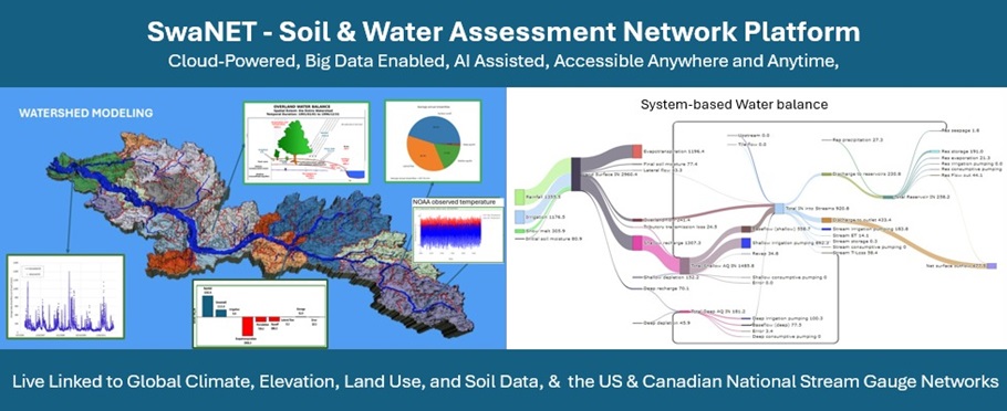
Feature / Option FREE PREMIUM Conceptual Water Balance Diagrams - Annotated with Average Simulated Fluxes Over Simulation Period or Selected Time Period ✔ ✔ Overland flow water balance ✔ ✔ Stream Water balance ✔ ✔ Reservoir water balance ✔ ✔ Shallow Aquifer Water Balance ✔ ✔ Deep Aquifer Water Balance ✔ ✔ Transient Water Balanc charts Line graphs of Daily, Monthly, or Yearly Fluxes Over Simulation Period or Selected Period ✔ ✔ Overland Flow Water Balance ✔ ✔ Stream Water Balance ✔ ✔ Reservoir Water Balance ✔ ✔ Shallow Aquifer Water Balance ✔ ✔ Deep Aquifer Water Balance ✔ ✔ System Topology Charts (Sankey diagrams) ✔ ✔ Watershed-level (Entire Model) Sankey Diagram ✔ ✔ Subbasin-level Sankey Diagram ✔ ✔
-
-
Flood mapping
-
Feature / Option FREE PREMIUM Flood Hazard Index mapping ✔ ✔ Flood Frequency Mapping ✔ ✔ Flood Reoccurence Mapping ✔ ✔
-
-
Downloadable Images
-
Feature / Option FREE PREMIUM Download in-platform Images/plotsto local machine Includes M4W logo No logo
-
-
Background Maps
-
Data Capabilities
-
Web Data Services for Big Data
-
Feature / Option FREE PREMIUM Big Data Published as Web Data Services - Web-based data/map Visualization and Model Building ✔ ✔
-
-
Direct Model-Data Linkages
-
Feature / Option FREE PREMIUM Watershed Boundary Extraction Based on Location and Scale of Interest ✔ ✔ DEM data Extraction ✔ ✔ DEM Upload Size 20 MB 200 MB DEM Download 90m and above All available DEM Use 1000x1000 pixels 10000x10000 pixels Land Use Data Extraction ✔ ✔ Land Use Map Upload Size 20 MB 200 MB Land Use Map Download 90m and above All available Land Use Map Use 1000x1000 pixels 10000x10000 pixels Soil Data Extraction ✔ ✔ Soil Map Upload Size 20 MB 200 MB Soil Map Download 90m and above All available Soil Map Use 1000x1000 pixels 10000x10000 pixels Climate Data Extraction (Historical/Current/Future) ✔ ✔ NOAA Climate Data Extraction (Observed) - US only 1 station User selected CFSR (Climate Forecast System Reanalysis) Cliamte Data Extraction - Global 1 station User selected PRISM Climate Data - US only -- User selected CMIP6 Data (Historical and Future Projections) - Global 5 years User selected
-
-
Sensor Data Extraction
-
Feature / Option FREE PREMIUM Historical and Realtime/Current Water Levels (stages) and/or Flow Rate from USGS Monitoring stream gaging stations (USA) or Environment Canada National Hydrometric Data Network ✔ ✔
-
-
Generic Web Data Services Importer
-
Feature / Option FREE PREMIUM Transfter WFS Layers (Vector Data) as Watershed from DataNET to SwaNET ✔ ✔ Transfter WCS Layers (Raster Data) as Input from DataNET to SwaNET ✔ ✔
-
-
Web Data Services for Big Data
-
AI Capabilities (free)
-
AI Powered Analytics, Insights, Reporting and Publication (coming soon)
-
Feature / Option FREE PREMIUM AI-generated Reports and Presentation Model Summaries, Detailed Descriptionns, Captioned figures ✔ ✔ Automated Model Parameter Table Generation -- ✔ On-demand Model Run-time Log Files Access ✔ ✔ Sub-basin based attribute tables/summaries ✔ ✔ Print (download) simulation output files ✔ ✔ Instantly Publish SwaNET models, reports, and/or data, etc to Global Model Network (see below) ✔ ✔ Save/Load SwaNET 3D visualizations to/from User Folder ✔ ✔
-
-
AI Powered Water Sustainability Learning Center (coming soon)
-
Feature / Option FREE PREMIUM Watershed Science AI-Assistant (AI Chat) Trained to engineering and scientific theory, case studies, open-source textbooks, etc. ✔ ✔ Case Study Gallery - Implementations & Applications of SwaNET ✔ ✔
-
-
AI Powered Water Sustainability Observatory Network (coming soon)
-
Feature / Option FREE PREMIUM Map Interface of Published Cyber-enabled Observatories (CEOs) - SwaNET models, Input/Output D, Reports, Graphics, Videos, Discussion, etc. ✔ ✔ AI-powered Search / Query/ Filter tools, Find models, Data, Reports, People etc … ✔ ✔ View CEO details Access Reports, Model Descriptions, Parameter Tables, Graphics, Videos ✔ ✔ Load Published Models Directly into SwaNET ✔ ✔
-
-
AI Powered Platform Support
-
Feature / Option FREE PREMIUM M4W Software and Modeling AI-Assistant (AI Chat) ✔ ✔ Realtime, Situational Help Pages ✔ ✔ Quick Tutorials ✔ ✔ Technical Reference Docs ✔ ✔
-
-
AI Powered Analytics, Insights, Reporting and Publication (coming soon)