Subcatchments are hydrologic units of land whose topography and drainage system elements direct surface runoff to a single discharge point. The user is responsible for dividing a study area into an appropriate number of subcatchments, and for identifying the outlet point of each subcatchment. Discharge outlet points can be either nodes of the drainage system or other subcatchments.
Subcatchments are divided into pervious and impervious subareas. Surface runoff can infiltrate into the upper soil zone of the pervious subarea, but not through the impervious subarea. Impervious areas are themselves divided into two subareas - one that contains depression storage and another that does not. Runoff flow from one subarea in a subcatchment can be routed to the other subarea, or both subareas can drain to the subcatchment outlet.
Infiltration of rainfall from the pervious area of a subcatchment into the unsaturated upper soil zone can be described using five different models:
- Classic Horton infiltration
- Modified Horton infiltration
- Green-Ampt infiltration
- Modified Green-Ampt Infiltration
- SCS Curve Number infiltration
To model the accumulation, re-distribution, and melting of precipitation that falls as snow on a
subcatchment, it must be assigned a Snow Pack object. To model groundwater flow between an
aquifer underneath the subcatchment and a node of the
drainage system, the subcatchment must be assigned a set of Groundwater parameters. Pollutant buildup
and washoff from subcatchments are associated with the Land Uses
assigned to the subcatchment. Capture and retention of rainfall/runoff using different types of
low impact development practices (such as bio-retention cells, infiltration trenches, porous
pavement, vegetative swales, and rain barrels) can be modeled by assigning a set of
predesigned LID controls to the subcatchment.
The other principal parameters for a Subcatchment are listed in the table below:
| Field | Description | ||||||
| Name | User-assigned subcatchment name. | ||||||
| X-Coordinate | Horizontal location of the subcatchment's centroid on the Study Area Map. If left blank then the subcatchment will not appear on the map. | ||||||
| Y-Coordinate | Vertical location of the subcatchment's centroid on the Study Area Map. If left blank then the subcatchment will not appear on the map. | ||||||
| Description | description of the subcatchment. | ||||||
| Rain Gage | Name of the rain gage associated with the subcatchment. | ||||||
| Outlet | Name of the node or subcatchment that recieves the subcatchment's runoff. | ||||||
| General | |||||||
| Area | Area of the subcatchment, including any LID controls (acres or hectares). | ||||||
| Width | Characteristic width of the overland flow path for sheet flow runoff (feet or meters). | ||||||
| % Slope | Average percent slope of the subcatchment. | ||||||
| % Impervious | Percent of the land area (not including any LIDs) which is impervious. | ||||||
| Roughness (N) | |||||||
| N-Imperv |
Manning's n for overland flow over the impervious portion of the subcatchment.
(Typical Value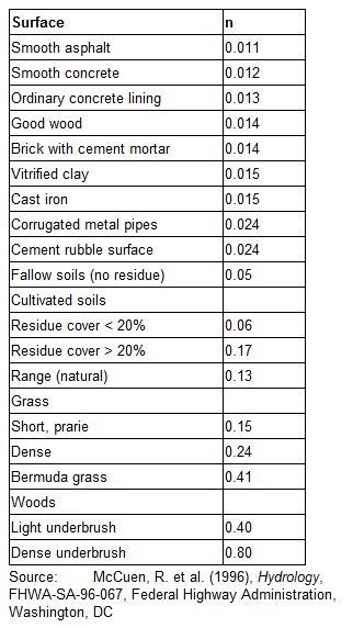 ) )
|
||||||
| N-Perv |
Manning's n for overland flow over the pervious portion of the subcatchment
(Typical Value)
|
||||||
| Storage (Dstore) | |||||||
| Dstore-Imperv |
Depth of depression storage on the impervious portion of the subcatchment (inches or millimeters)
(Typical Value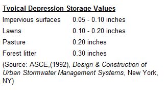 ) )
|
||||||
| Dstore-Perv |
Depth of depression storage on the pervious portion of the subcatchment (inches or millimeters)
(Typical Value)
|
||||||
| % Zero-Imperv | Percent of the impervious area with no depression storage. | ||||||
| Routing | |||||||
| Subarea Routing |
Choice of internal routing of runoff between pervious and impervious areas:
|
||||||
| Percent Routed | Percent of runoff routed between subareas. | ||||||
| Other Tabs | |||||||
| Infiltration | Click the Infiltration/Pullutants/Land Uses (2nd) tab to edit infiltration parameters and see detailed help. | ||||||
| Land Uses | Click the Infiltration/Pullutants/Land Uses (2nd) tab to assign land uses to the subcatchment. Only needed if pollutant buildup/washoff modeled. | ||||||
| Initial Buildup and Curb Length | Click the Infiltration/Pullutants/Land Uses (2nd) tab to specify initial quantities of pollutant buildup over the subcatchment and the length of curbs. | ||||||
| LID Controls | Click the Low Impact Development(3rd) tab to edit the use of low impact development controls in the subcatchment and see detailed help. | ||||||
| Groundwater | Click the Groundwater Flow (4th) tab to edit groundwater flow parameters for the subcatchment and see detailed help. | ||||||
| Visualization | Click the Visualization Parameters (5th) tab to edit CAD 3D display for the subcatchment and see detailed help. | ||||||
| Snow Packs | |||||||
| Snow Pack | Name of snow pack parameter set (if any) assigned to the subcatchment. | ||||||
| Time Pattern | |||||||
| N-Perv Pattern | Name of optional monthly Time Pattern adjustments applied to pervious Manning's n (N-Perv). Leave blank if not applicable. | ||||||
| Dstore Pattern | Name of optional monthly Time Pattern adjustments applied to both depression storage (Dstore) values. Leave blank if not applicable. | ||||||