|
|
|
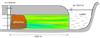
Impact Analysis of Infrastructure Development on Groundwater-fed Wetlands
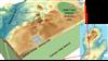
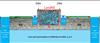
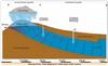
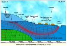
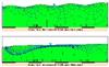
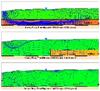
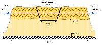
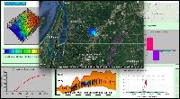
ADVANCED – Integrated groundwater modeling project; flow tracking; infrastructure impact analysis. Background: Under consideration is the construction of a permanent facility at Fort Custer Training Center (FCTC) in southwest Michigan, which may potentially impact the existing environmental conditions. Regulations require that an Environmental Impact Statement (EIS) be conducted and this hydrologic analysis is an integral component of that larger study. In particular, the FCTC has multiple groundwater-fed streams and wetlands, including the globally unique and sensitive prairie fen wetland distinction. Groundwater-fed water resources are desirable for numerous reasons; especially from an ecological perspective. This is due to their extreme biodiversity as prairie fens serve as a habitat for rare, threatened, or endangered species.
(Numerical Flow Modeling III- 20),(Science in the Court Room- 14)
|
|

|
|
Lake / Aquifer Eutrophication and the Sewer Project
Intermediate to Advanced - Contaminant mass balance in mixed systems; groundwater-lake coupling. Background: A sewer construction program has been proposed as a method of controlling eutrophication in a small lake which is surrounded by suburban community. The lake receives practically all of its water from a phreatic groundwater system which surrounds the lake. Evaporation from the lake surface is equal to precipitation. Suburban development is distributed throughout the groundwater basin. Domestic waste water is currently discharged into individual septic tanks which drain to the groundwater system. Water supply is also obtained from the ground and consumptive use is small.
(Lumped Parameter Models- 8)
|
|

|
|
St Johns Landfill
Beginner to Advanced – Multi-step Problem, which can be done sequentially (as a project) or individually (as assigned problems).
Background:
The St Johns landfill is a 225 acre landfill located in North Portland, Oregon, near the confluence of the Columbia and Willamette Rivers. The landfill sits on a thick layer of silt (average thickness ~50ft), which in turn overlies a fairly transmissive gravel aquifer. The aquifer covers the entire area between the Columbia and Willamette rivers and extends east past North Portland Road. It is known the aquifer is well connected (hydraulically) with the two rivers
(Numerical Transport Modeling II- 7)
|
|
|
|
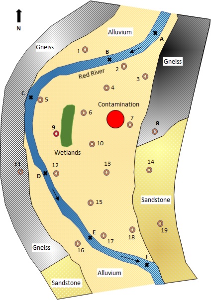
Interlachen, Oregon groundwater contamination
Intermediate – Multi-layer aquifer modeling; source water tracking; contaminant tracking. Background: A small community pumps groundwater from a confined sandstone aquifer for their drinking water supply. A recent monitoring study, however, shows that the aquifer is contaminated by a TCE plume near the Boeing and Cascade sites upgradient (see below). Although the well water is currently not contaminated, the citizens are extremely concerned since groundwater is their exclusive source of water supply.
(Numerical Flow Modeling III- 20),(Numerical Transport Modeling II- 7)
|
|
|
|
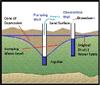
Well Interference Dispute II
Beginner to Advanced - analytical and numerical sub-problems, which can be done sequentially or individually. Background: A dispute has arisen between two farmers after one of the farmers installed a 500 GPM irrigation well 2000 ft. from the small domestic water supply well of the other farmer (see above). After the irrigation well had been operating for 3 months it was observed that the water level in the domestic well had declined over 30 feet. The owner of the domestic well claims that the decline in water level in his well is due to pumping from the irrigation well and is trying to restrict that pumping. The owner of the irrigation well claims that the decline is related to the recent drought; he has been advised that the "radius of influence"" of his well is at most 500 feet."
(Well Hydraulics - 14),(Numerical Flow Modeling II - Unsteady- 22),(Science in the Court Room- 14)
|
|

|
|
Subsurface Heterogeneity
Lesson (under development). Background: Groundwater occurs in the geological formations of the subsurface. An understanding of how geological materials are distributed, how they formed, and the changes they have undergone is therefore of key importance to hydrogeologists, groundwater hydrologists, etc. In this exercise, we review the different processes that generate different geologic features/patterns, and explore ways for qualitatively and quantitatively characterizing the heterogeneity of the subsurface.
(Aquifer Properties & Heterogeneities- 14)
|
|

|
|
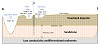
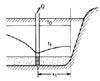
Canyon Seepage
Beginner to Intermediate -- Analytical and numerical components. Background: A sandstone aquifer connects a reservoir with a river in a canyon as shown below. Impermeable shale lies above and below the aquifer, and along the river and reservoir where the aquifer is not connected. A portion of the aquifer near the river is unconfined.
(Analytical Flow Modeling - Steady- 12)
|
|

|
|
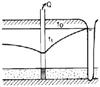
Groundwater Mounding and Baseflow Regression Dynamics
Intermediate to Advanced - Application of analytical solutions. Background: Consider the mounding of groundwater between two streams draining an unconfined aquifer (see Figure 1). A common practice is to analyze the flow in the system by assuming predominantly horizontal flow in the aquifer. The analysis may be further simplified by assuming that the change of the saturated thickness along the direction of flow (x-direction) of the aquifer is small compared to the average saturated thickness.
(Analytical Flow Modeling - Unsteady- 10),(Numerical Flow Modeling II - Unsteady- 22)
|
|

|
|
Groundwater Remediation - Videos Exercise
Beginner - Watch videos and respond. Background: The past decades of industrialization and urbanization, intensive farming and deforesting, and other activities of modern society has left a legacy of groundwater contamination across the world. Thus, s=an important topic in groundwater science and engineering is the cleanup of contamination groundwater, or groundwater remediation.
( Effects of Heterogeneity on Transport- 9),(Groundwater Remediation- 6)
|
|
|
|
Groundwater Contamination Videos Exercise
Watch videos and respond. Background: Modern civilizations have a profound impact on groundwater quality. From industrialization and urbanization associated with 21st-century `mega cities' and population increase, to intensive farming and deforesting, there is a significant use of resources and generation of waste that make groundwater unsuitable for use. Examples of groundwater contaminants include dissolved inorganic substances (e.g., chloride, sulfate, etc.) or organic liquids, dissolved organic/inorganic constituents, or pathogens from anthropogenic sources.
(Global Water Issues- 9)
|
|
|
|
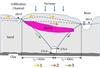
Landfill Fluxes and Offsite Migration
Intermediate - Analytical and numerical sub-problems. Originally a network of sloughs, lakes and wetlands, a piece of land has been converted into an open-pit landfill to dispose of refuse of a nearby population center. Solid waste continues to pile up, creating a leachate mound in the landfill that serves as a driving force for vertical and lateral loading of contaminants into a sand and gravel aquifer and the sloughs, respectively. Local residents are concerned about the impact on the surface water (used for fishing and recreational purposes) and groundwater (used for drinking water supply).
(Numerical Transport Modeling I- 20)
|
|

|
|
Aquifer Storage Mechanisms
Beginner to Intermediate - Watch videos and respond.
1. Explain the difference in storage mechanisms in confined and unconfined aquifer. What are the key factors that dictate the magnitude of the two different storage coefficients?
2. Watch the following videos and comment on the dramatic difference between confined and unconfined aquifer dynamics.
(Aquifer Properties & Heterogeneities- 14)
|
|
|
|
|
Well Conflict Resolution
Beginner to Advanced - analytical and numerical sub-problems, which can be done sequentially or individually. Background: A dispute has arisen between two farmers after one of the farmers installed a 500 GPM irrigation well 2000 ft. from the small domestic water supply well of the other farmer (see above). After the irrigation well had been operating for 3 months it was observed that the water level in the domestic
(Well Hydraulics - 14),(Science in the Court Room- 14)
|
|

|
|
Plume Capture
Intermediate - Analytical and numerical sub-problems. A number of techniques exist for removing or greatly reducing groundwater contamination. One method commonly practiced is hydrodynamic isolation or passive plume capture. An extraction well positioned downgradient of the leading edge of the plume will help to stabilize the position of the plume, allowing the contaminated water to then be pumped out of the aquifer. Contaminated groundwater is sometimes treated before disposal or discharge back to the environment.
(Capture Zone Analysis- 14)
|
|
|
|
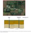
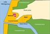
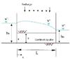
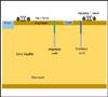
Lake Augmentation Well
Intermediate to Advanced. Multi-layer aquifer modeling; pumping and water balance analysis. Background: Little Lake is a shallow, highly utilized residential and recreational area, but has recently experienced falling water levels due to a relatively dry period. Residents and recreational users are concerned over related negative impacts, e.g., lower real estate values, poor boat navigation, etc. A lake augmentation well - which will pump groundwater from a deep aquifer (Aquifer B) directly into Little Lake - has been suggested as a way to restore lake levels. A thin aquitard layer exists between Aquifer B and the shallow aquifer (Aquifer A), but well production tests near the lake suggest a break in the layer exists at some unknown distance from the far side of the lake (see Figure 1). The high-flow, deeply incised Grand River is situated approximately 2000m from the lake / proposed augmentation well location.
(Numerical Flow Modeling I - Steady State- 12)
|
|
|
|
Accidental Pesticide Spill - I
As a result of a labeling error, a banned water-soluble pesticide was accidentally applied over an
agricultural area.
The area is drained by a small creek which sustains the flow entirely as a result of subsurface drainage from the
agricultural area. Inhabiting the creek is the largest known population of a rare and endangered
species of minnow which is particularly sensitive to environmental contamination. Concentrations of the
pesticide greater than 50 ppb are known to be toxic to this species of minnow.
The state environmental agency proposed to do a 9 mo., $500,000 sampling and modeling study before recommending any action.
Environmentalists propose that a soil-treatment process applied to the upper 20 cm of the soil be initiated immediately. This will cost several million dollars and involved tilling of the soil which would destroy the crops.
The farmers have suggested that the problem be solved by capturing the minnows and holding in a fish hatchery for a few months until the creek contamination has cleared. You are hired to develop a quantitative analysis of these proposals.
(Lumped Parameter Models- 8),(Featured Active Learning Projects- 24)
|
|

|
|
Visualizing Numerical Dispersion
Intermediate to Advanced - Numerical aspects of groundwater modeling. Background: Real-world contaminant transport problems are often complex beyond the assumptions of analytical solutions, so numerical solutions of the transport equation are often utilized. But when comparing simple numerical solutions to exact analytical solution, an extra dispersion (or spreading) of the contaminants is observed in the numerical solution. This is called numerical dispersion or `numerical dilution'.
(Transport & Transformation Processes- 14)
|
|
|
|
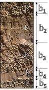
Layered Heterogeneity
Beginner to Intermediate - Theoretical application. Background: At regional scales, sedimentary rocks and unconsolidated lacustrine and marine deposits often exhibit a vertically-layered heterogeneity, with each individual bed (or layer) in the formation having a homogenous conductivity value K1, K2, etc (see Figure 1). Such layered heterogeneity can result in significant contrast in hydraulic conductivity within a layer sequence (i.e., several orders of magnitude).
(Aquifer Properties & Heterogeneities- 14)
|
|

|
|
Leaky Aquifer to a Lake
Intermediate - Analytical approach (numerical sub-problem under development). Background: One of the primary delivery mechanisms of chemicals into lakes is the discharge of groundwater through lakebed sediments. The transfer of chemicals and nutrients such nitrogen and phosphorus, carbon, etc. affects the biological processes in the lake and helps to control the biochemical characteristics of the lakes and co-dependent ecosystems (including those downstream of the lake).
(Analytical Flow Modeling - Steady- 12)
|
|

|
|
Stream BioStation Wells
Intermediate - Analytical and numerical sub-problems. Scientists staying at a streamside biological station rely on a shallow, hand-dug water well to support their water needs during extended field visits. Recently, a large-scale horticulture center (greenhouse complex) was built nearby, requiring the extraction of large amounts of groundwater from the unconfined aquifer as the ecologically important stream is protected from any water abstractions. It is known that the stream and aquifer are well connected.
(Numerical Flow Modeling I - Steady State- 12)
|
|
|
|
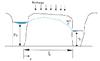
Dewatering Impact Analysis
Dune Shores LLC is proposing to construct a 17 ft deep boat marina near Lake Mishigamaa at the mouth of the Gitchi River. But they are running into fierce opposition from the local community and environmental activists who argue that the excavation of the new marina will cause the surrounding water table to decline, including in the area of several important interdunal wetland ecosystems. You be the judge … would the proposed plan by the developer work? Should permits be issued by the Army Corps of Engineers and the DEQ?
(Numerical Flow Modeling III- 20)
|
|
|
|
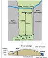
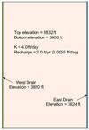
Water supply expansion and wetlands
Intermediate - 2D flow modeling and water balance analysis. Background: The town of Hubertville is planning to expand its water supply by constructing a pumping well in an unconfined aquifer. The well is designed to pump constantly at a rate of 20,000 m3/day. Well construction was halted by the State Fish and Game Service who manage the Green Swamp Conservation area. The agency claimed that pumping would “significantly reduce” groundwater discharge to the swamp and damage a waterfowl habitat. The town claimed the fully penetrating river boundary to the north and the groundwater divide located near the center of the valley would prevent any change in flow to the swamp.
(Numerical Flow Modeling I - Steady State- 12),(Stream Depletion - 8),(Science in the Court Room- 14)
|
|
|
|
Streamflow Depletion
Intermediate to Advanced - Multi-layer aquifer modeling. Background: In almost all streams, there is movement of water between the underlying groundwater and the surface water body. Because of this interaction, depletions to streams due to pumping can occur either by wells that intercept water that otherwise would have flowed to the surface water bodies or by causing water to move from the streams to the well. Pumping-induced reductions in base flow are not instantaneous nor do they occur only to streams closest to the well. There can be significant interaction among surface water bodies and it can take years or decades for depletions to be fully realized.
(Numerical Flow Modeling I - Steady State- 12),(Stream Depletion - 8)
|
|
|
|
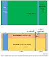
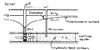
Wellhead Protection
Intermediate - Flow modeling; source water tracking; contaminant tracking. Background: A small community pumps groundwater from a confined sandstone aquifer for their drinking water supply (see figure). A recent monitoring study, however, shows that the aquifer is contaminated by a TCE plume near an industrial site upgradient of the community well. Although the well water is currently not contaminated, the citizens are concerned since groundwater is their exclusive source of water supply.
(Numerical Flow Modeling I - Steady State- 12)
|
|

|
|
Transport Processes
Beginner- Watch videos and respond. Background: Groundwater contaminants move through groundwater systems because of a number of processes. Watch videos on “Transport processes” under education video at www.magnet4water.com, and explain the relative importance of the different processes that control the fate and transport of contaminants in a real-world aquifer.
(Transport & Transformation Processes- 14)
|
|
|
|
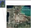
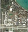
East Bay Township Plume Clean-up Project - HONORS
Advanced - Multi-week integrated groundwater project. Flow modeling; contaminant remediation. Background: A subsurface contaminant plume has been identified in East Bay Township, a residential area adjacent to Traverse City, Michigan and home to the Cherry Capital Airport. Prompted by complaints of odors and foaming water in domestic water well supplies in the residential area along Avenue E near East Grand Traverse Bay, the Department of Public Health detected organic substances in the groundwater – including benzene, toluene, xylene, and other compounds characteristic of solvents, cleaning agents, and fuel substances. These chemicals are known to be harmful if ingested by humans.
(Numerical Flow Modeling III- 20),(Numerical Transport Modeling II- 7),(Groundwater Remediation- 6)
|
|
|
|
East Bay Township Plume Clean-up Project
Advanced - Multi-week integrated groundwater project. Flow modeling; contaminant remediation. Background. A subsurface contaminant plume has been identified in East Bay Township, a residential area adjacent to Traverse City, Michigan and home to the Cherry Capital Airport. Prompted by complaints of odors and foaming water in domestic water well supplies in the residential area along Avenue E near East Grand Traverse Bay, the Department of Public Health detected organic substances in the groundwater – including benzene, toluene, xylene, and other compounds characteristic of solvents, cleaning agents, and fuel substances. These chemicals are known to be harmful if ingested by humans.
(Numerical Flow Modeling III- 20),(Numerical Transport Modeling II- 7),(Groundwater Remediation- 6)
|
|
|
|
MAGNET OVERVIEW slides
Overview slides of MAGNET - a data-enabled modeling system built on pre-processed, fully-assembled framework data, i.e., data needed to conceptualize and characterize the system in a ready-to-use form at the global scale. The system allows users not only to access and utilize pre-processed big datasets, but also to do so in real-time and interactively.
(Data-enabled Modeling Platform- 17)
|
|

|
|
MAGNET TUTORIAL - Integrated Site Problem Solving
This tutorial provides step-by-step instructions for simulating one of the largest groundwater contamination plumes in the United States – and the largest TCE (trichloroethlylene) plume in Michigan. The source of the contamination is degreasing solvents used at the Wickes Manufacturing plant in the small town of Mancelona during the 1940s and ‘50s. Originally disposed into shallow pits on site, the TCE plume has migrated northwest in the surficial glacial aquifer, toward a well field providing drinking water to private properties and municipalities. TCE is a known carcinogen.
(Data-enabled Modeling Platform- 17)
|
|

|
|
Groundwater Refraction
When groundwater flowlines cross a geological boundary between formations with different values of hydraulic conductivity, they refract, much as light does when it passes from one medium to another. Watch the related videos and answer the questions that follow.
(Flow Net & Refraction- 7)
|
|
|
|
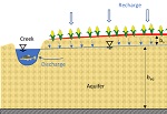
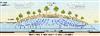
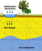
Recharge Area vs Discharge Area
Groundwater recharge or deep drainage or deep percolation is a hydrologic process, where water moves downward from surface water to groundwater. Recharge is the primary method through which water enters an aquifer. Watch the MAGNET video and answer the questions that follow.
(Aquifers & Geology- 16)
|
|
|
|
Recharge Area for a Confined Aquifer
A recharge area is the place where water is able to seep into the ground and refill an aquifer because no confining layer is present. Recharge areas are necessary for a healthy aquifer. Watch the MAGNET video below and answer the questions that follow.
(Aquifers & Geology- 16),(Unsaturated Flow & Recharge- 4)
|
|
|
|
Losing Streams vs. Gaining Streams
Gaining streams are supplied with water from groundwater, and losing streams lose stream water to groundwater. Therefore gaining streams have water flowing year‐round or for extended periods such as wet seasons, whereas losing streams tend to have flow only in response to water‐input events like rainfall and otherwise have no flow. Watch the following MAGNET videos and answer the questions that follow.
(Surface & Ground Water Interaction- 8)
|
|
|
|
Groundwater vs Surface Water-fed Lakes, Flow Through Lakes
nder most situations, groundwater and surface water are hydraulically connected. A lake, stream, or wetland either receives water or provides water to the underlying aquifer in the form of bed or bank seepage. In some cases, a lake or wetland can both simultaneously receive water from and provides water to the aquifer below.
(Surface & Ground Water Interaction- 8)
|
|
|
|
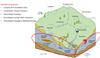
Regional Vertical Circulation 1
Decades of groundwater hydrology research and modeling has demonstrated that flow in the subsurface environment is complex. It consists of shallow and deep flow systems; it is multiscale - a hierarchical system or system of systems. Watch the related videos, answer short questions, and re-create the animations/models using MAGNET.
(Vertical Regional Circulation- 7),(Profile Modeling- 6)
|
|
|
|
The paths of least resistance
Groundwater flows in the path of least resistance. At each point in it’s journey, it will “select” the next point to go to. So every adjacent point uses the least energy to move to the next point. Modeling groundwater flow is essentially a systematic process to identify and delineate these optimal, least resistance flow paths, connecting recharge points (areas) to discharge points (areas). Watch the related videos, answer short questions, and re-create the animations/models using MAGNET.
(Vertical Regional Circulation- 7)
|
|

|
|
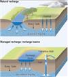
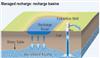
Artificial Recharge
Artificial Storage and Recovery (ASR) facilities inject treated wastewater or surface water into an aquifer. Some ASR facilities inject groundwater from a different aquifer. Watch the related videos, answer short questins, and reproduce the animations/models using MAGNET
(Analytical Flow Modeling - Steady- 12),(Aquifer Storage & Recovery- 5)
|
|

|
|
Groundwater Contamination - Introduction
Virtually any activity whereby chemicals or wastes may be released to the environment, either intentionally or accidentally, has the potential to pollute ground water. When ground water becomes contaminated, it is difficult and expensive to clean up. What the related video and answer the short questions that follow.
(Global Water Issues- 9)
|
|
|
|
Random Field Representation of Heterogeneity
Modeling explicitly the effect of small scale heterogeneities using traditional deterministic approaches is considered impractical. The alternative is to utilize a small number of scattered samples to estimate the variability of parameters in a statistical framework. That is, the spatial variation of a hydraulic property is characterized by its probability distribution estimated from samples. Watch the related videos, answer short questions, and re-create the animations/models using MAGNET. Also, perform a sensitivity analysis of the random field model with respect to key parameters characterizing the random field.
(Stochastic Flow & Transport Modeling- 15)
|
|
|
|
Variability, Uncertainty, and Likely Plume Realizations
Hydraulic conductivity values vary significantly in space, although the variation is not entirely random, but correlated in space. Such a correlated nature implies that the parameter values are not statistically independent in space and they must be treated as a stochastic process, instead of as a single random variable. Watch the related videos, answer short questions, and re-create the animations/models using MAGNET.
(Stochastic Flow & Transport Modeling- 15)
|
|
|
|
Probabilistic Modeling of Solute Plume Dynamics
Aquifers are inherently heterogeneous at various observation scales. Characterizing the heterogeneity at a scale of our interest generally requires information of hydrological properties at every point in the aquifer. Such a detailed hydraulic property distribution in aquifers requires numerous measurements, considerable time, and great expense, and is generally considered impractical and infeasible. The alternative is to utilize a small number of samples to estimate the variability of parameters in a statistical framework. Watch the related videos, answer the short questions, and re-create the animat
(Stochastic Flow & Transport Modeling- 15)
|
|
|
|
|
Bank Seepage & Springs
Bank Seepage is the natural diffuse discharge of groundwater into a river or lake along its banks. If concentrated in a particular area, a seepage may more accurately be called a spring.
(Surface & Ground Water Interaction- 8)
|
|
|
|
Human Influences on Groundwater Availability
Prior to a recent knowledge about groundwater resources, it was commonly thought that groundwater was so isolated from the land surface that it was unaffected by human activities. As a more complete scientific understanding of groundwater developed, it became clear that large-scale agricultural practices and expanded urban centers created groundwater issues. Learn more in this introductory reading lesson!
(Hydrological Cycle - 6)
|
|
|
|
Radius of Influence
The Radius of Influence, R(t), is the horizontal radial distance from a well to the points in an aquifer where there is negligible influence from pumping. Show that R(t) is proportional to sqrt(T/St); explain why why the impact of pumping on a confined aquifer is dramatically larger than that on a unconfined aquifer; and develop a MAGNET model that can reproduce the Theis solution and perform a sensitivity analysis with respect to hydraulic conductivity, storage coefficient, and time.
(Well Hydraulics - 14)
|
|
|
|
Seawater intrusion (salt water intrusion)
Seawater intrusion in coastal aquifers is a widespread and serious problem in many parts of the world. Groundwater degradation due to seawater intrusion is often accentuated in small island aquifers due to overpumping or limited replenishing amounts of precipitation. Solve an example problem analytically and numerically using MAGNET.
(Analytical Flow Modeling - Steady- 12)
|
|
|
|
Specific Capacity
Specific capacity is defined as the rate of discharge of a well per unit depth of drawdown. Probe analytical solutions and develop a MAGNET model to simulate flow in a specific area given specific capacity measurements distributed across space.
(Well Hydraulics - 14)
|
|
|
|
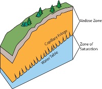
Unsaturated Zone
Definition and graphic.
(Hydrological Cycle - 6),(Unsaturated Flow & Recharge- 4)
|
|

|
|
Effective Hydraulic Conductivity - Applied Lanfill Problem
A leachate mound in the landfill serves as a driving force for vertical and lateral loading of contaminants into a sand and gravel aquifer and the surrounding sloughs, respectively. Calculate the flux of leachate (seepage flux and contaminant flux) and travel times from the landfill to the sloughs and underlying aquifer, and use MAGNET to simulate leachate offsite migration in the deep aquifer.
(Darcys Law & Effective Conductivities - 13)
|
|
|
|
Water Withdrawal Assessment
When pumping near a stream, we are interested not only in the resulting drawdowns, but also in the depletion of the stream flow, resulting in potentially adverse impact of groundwater dependent ecosystems. Develop a more general MAGNET numerical model that can reproduce the above analytical solution and perform a sensitivity analysis of stream depletion with respect to the following parameters: aquifer conductivity; storage coefficient; regional hydraulic gradient; stream bed leakance; heterogeneity; presence of other interacting sources and sinks.
(Well Hydraulics - 14),(Surface & Ground Water Interaction- 8),(Numerical Flow Modeling II - Unsteady- 22),(Stream Depletion - 8)
|
|
|
|
Aquifer Flushing/Cleanup using a Drainage Gallery and Infiltration Channel
There was an incident with a cargo train that resulted in a major accidental spill of harmful chemicals. The contaminated groundwater is migrating toward a river used for drinking water supply for a large population center. Construction of a drainage gallery and an infiltration channel for aquifer flushing is proposed for the cleanup of the contaminant plume. Develop a MAGNET model of the groundwater inflow into the drainage gallery for the given parameters/conditions. Also solve the problem analytically and compare the results.
(Analytical Flow Modeling - Steady- 12),(Groundwater Remediation- 6)
|
|

|
|
Confined Heterogeneous Aquifer
Calculate the groundwater flow per unit width of a confined aquifer which can be divided into three homogeneous areas with different hydraulic conductivities. Also determine the position of the piezometric surface on the cross-section and the "equivalent hydraulic conductivity". Solve the following problem analytically and using MAGNET and compare the results.
(Analytical Flow Modeling - Steady- 12)
|
|
|
|
Dam break and basement flooding dispute
Those Dam Guys LLC was contracted to take on an controversial project - removing the Plankton Dam along an otherwise picturesque stretch of the Plankton River. While they were using a control structure to drawdown the water level in the reservoir, the system failed, causing the downstream river levels to rise by 4m. Several citizens sued Those Dam Guys, claiming their basements were damaged because of the rising groundwater levels caused by high river levels after the dam break. The consultants argued that the basement flooding due was to the inherent surface drainage issues in the clay rich floodplain area, and had nothing to do with river level rise after the dam break. You be the judge..is Those Dam Guys LLC responsible??
(Model Calibration - 5),(Analytical Flow Modeling - Unsteady- 10),(Numerical Flow Modeling II - Unsteady- 22),(Science in the Court Room- 14),(Featured Active Learning Projects- 24)
|
|
|
|
Construction Dewatering - Confined and Unconfined Aquifer Transitioning
An extraction well on a large river island has been considered for a temporary lowering of the piezometric surface for construction purposes. The island's sandy aquifer, which is naturally confined, will have to undergo a change to unconfined conditions at the construction site because of the requirement that the piezometric surface must be kept at 1.5 meters below the aquifer top during the construction. Find the pumping rate at the well that will satisfy this requirement for safe constriction. Use both an analytical approach and numerical approach.
(Numerical Flow Modeling III- 20)
|
|
|
|
Bank Filtration and Well Field Design for a Large-scale Water Supply
The possibility of developing a well field taking advantage of bank filtration for large scale water supply is being studied for the unconfined aquifer. The aquifer is developed in the alluvial sand deposits of perennial river. Using the provided information and MAGNET, develop a preliminary groundwater model for assessing the aquifer’s potential and designing the pumping network.
(Numerical Flow Modeling III- 20),(Stream Depletion - 8)
|
|
|
|
Storage Coefficients and Mechanisms
The property which expresses the capacity of an aquifer to take water into and release water from storage is called “storativity” for a confined aquifer and “specific yield” for an unconfined aquifer. Watch the related MAGNET videos and answer the short questions that follow.
(Aquifer Properties & Heterogeneities- 14)
|
|

|
|
Hydraulic Conductivity Heterogeneity
Hydraulic conductivity can vary by orders of magnitude in the subsurface, depending on the size, shape and interconnectedness of the pores or open spaces between solid materials. Calculate the effective vertical hydraulic conductivity of the stratified formation between a lake and an aquifer. Also compute the vertical seepage flux from the lake to the aquifer using the Darcy's law based on the effective conductivity. Verify the results using MAGNET.
(Aquifer Properties & Heterogeneities- 14)
|
|
|
|
Polluted river
Surface water migrates into the groundwater by infiltration through the soil, or by runoff into areas where the water table is above the surface of the ground. Use MAGNET to model the impact of a contaminated stream on a nearby drinking water well, and numerically experiment with the effect of stream leakage coefficient (or leakance) characterizing stream-aquifer connection.
(Numerical Transport Modeling I- 20)
|
|
|
|
Recharge
Definition and graphic.
(Boundary and Initial Conditions- 11),(Unsaturated Flow & Recharge- 4)
|
|
|
|
The Two-faced Stream!
An interesting phenomenon, observed on a winter hydrogeology field trip: a sharp contrast in the flow condition between two stretches in a first order stream (creek) . One stretch was icy (mostly frozen), while another stretch from was not. Build a MAGNET model to explain it.
(Numerical Flow Modeling I - Steady State- 12)
|
|
|
|
Looking for Groundwater Dependent Ecosystems
Water seeps most frequently occur at the base of hillsides composed of glacial deposits. Springs arise from water bubbling up from the surface soil that is usually a light-grey colored marl. Watch the related videos and answer short questions.
(Vertical Regional Circulation- 7)
|
|
|
|
Flow Through Lakes
Flow-through lakes are surface expressions of the water table and are in direct hydraulic connection with the water-table aquifer. They receive inflows from groundwater along the upgradient shore of the lake and discharge flow to groundwater along the downgradient shore. In general, the net contribution of groundwater to the overall lake water balance is zero (although some net loss of groundwater from evaporation may take place).
(Surface & Ground Water Interaction- 8)
|
|

|
|
Capture Zone with and without Dispersion
Application of the particle tracking technique for the delineation of capture zones can sometimes be misleading - because it is only based on advection and does not take into consideration transport parameters, such as dispersion, diffusion, absorption etc. Watch the related videos, answer short questions, and re-create the animations/models using MAGNET.
(Capture Zone Analysis- 14)
|
|
|
|
Critique of a Conceptual Groundwater Flow Model
Barron Lake, just East of Niles in Van Buren County, had significant water loss during the 2012 drought and conditions have not rebounded.The community has been exploring various options to augment the lake (raise the lake level) and one of them under active consideration involves pumping groundwater from a confined aquifer near the lake and adding the water pumped back to the lake. Critique the conceptual groundwater flow model proposed by a consultant that concluded, YES, the the augmentation project is feasible.
(Numerical Flow Modeling I - Steady State- 12)
|
|
|
|
A Multi-Cell Lumped Parameter Model
A multi-cell, lumped parameter model is also known as Tank model for regional groundwater flows. It has the advantage of being computationally very efficient, and is particularly useful / needed when data available is limited. Consider a four-cell aquifer model of specified dimensions and natural replenishment. Find the steady-state head in each cell relative to the river elevation using an analytical approach. Solve the problem using MAGNET and compare the results.
(Lumped Parameter Models- 8)
|
|
|
|
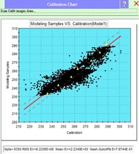
Calibration
Definition and supporting graphics.
(Model Calibration - 5)
|
|
|
|
Small scale Heterogeneity vs Large Scale Anisotropy
It is well know that hydraulic conductivity field in real-world aquifers are strongly heterogeneous, exhibiting multiple scales of variations. Use MAGNET to demonstrate small scale heterogeneity has large sale implications: small scale heterogeneites translate into large scale anisotropy.
(Darcys Law & Effective Conductivities - 13)
|
|

|
|
Wellhead protection area, heterogeneity, and preferential channels
Capture zones of wells play an important role in groundwater protection. However, the shape and size of a catchment zone cannot be determined exactly due to inherent heterogeneities/uncertainty of aquifer parameters. Use MAGNET to probabilistically delineate a well capture zone, taking into account the uncertainty in the aquifer parameters.
(Capture Zone Analysis- 14)
|
|

|
|
WHPA - Time of Travel
The time required for a particle of water to move in the saturated zone from a specific point to a well is the Time of Travel (TOT). A line can be drawn around the area for which groundwater is expected to reach the well within a chosen period. Watch the related video, answer short questions, and re-create the animation/model using MAGNET.
(Capture Zone Analysis- 14)
|
|

|
|
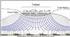
Regional Vertical Circulation Lesson
Introductory-level Lesson. The focus of this exercise is regional circulation of water within a groundwater basin - a defined volume of the subsurface through which groundwater flows from areas where the water table is recharged to a location where groundwater discharge occurs. This movement is a three-dimensional phenomenon, but we will use two-dimensional (vertical cross section) flow net diagrams to effectively illustrate some generalized flow system features and the effects of heterogeneity and anisotropy
(Vertical Regional Circulation- 7),(Profile Modeling- 6)
|
|

|
|
Stream Aquifer Interaction
(Lesson - Under Development) Beginner. This exercise explores the impact of stream stage fluctuations on adjacent aquifer systems (both unconfined and confined). Part I involves qualitatively describing the key parameters and relationships controlling groundwater response to stream fluctuations through the analysis of (vertical cross-section) profile models. Part II presents the mathematical framework of stream-aquifer interaction, giving students the opportunity to quantify groundwater dynamics and infer aquifer properties from observational data.
(Analytical Flow Modeling - Unsteady- 10),(Surface & Ground Water Interaction- 8),(Numerical Flow Modeling II - Unsteady- 22)
|
|

|
|
Lake Augmentation
Home owners from a beautiful lake community faced a water problem: their lake was ‘sick’ – it was losing water and lake levels were getting lower. An expert "fixed" the problem by pumping deep groundwater directly into the lake. But years layer, the same problems returned. A second expert says the plan never really worked in the first place. Determine if the lake augmentation project was doomed from the beginning.
(Numerical Flow Modeling III- 20)
|
|

|
|
Drinking Water Contamination Dispute
Homeowners in a small community filed a lawsuit against a nearby food processing plant for the contamination of their water wells with heavy metals. They claimed that the source of the problem is the food processing company’s spray irrigation of its waste water at four large fields in the vicinity. But the food processing company denied the charges, arguing that even if the water from the spray irrigation is a problem, it cannot possibly reach most of the water wells because they are outside the impact area of the spray irrigation. You be the judge… is the company responsible?!?
(Numerical Flow Modeling III- 20),(Numerical Transport Modeling II- 7)
|
|

|
|
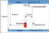
Groundwater Model Calibration Exercise - Fluxes and SWLs
Planning to install a new 250 GPM well at their main facility, a small manufacturer hires you to determine whether their proposed well will cause any problems with the stream and an existing well and whether the new well or the existing well would likely become contaminated by a nearby TCE plume as a result of the operation of the new well. The new well will be operated continuously. The party responsible for the TCE plume has only recently been notified that they must remediate this plume. The State DEQ expects that it will be several years before this happens since it appears the State will have to go to court to force compliance.
(Numerical Flow Modeling III- 20),(Model Calibration - 5),(Featured Active Learning Projects- 24)
|
|

|
|
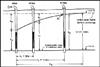
Irrigation Drainage System
(Intermediate - Analytical and numerical sub-problems.) The irrigation system for the Spartan valley is to control the water table at a minimum of 3.5 ft below the ground surface. This is done to prevent flooding in agricultural fields which can damage or completely destroy crops. The proposed solution is to create a system of 6ft. deep parallel ditches that `remove' groundwater through surface seepage, such that the water table does not rise to a depth less than the minimum allowable depth (see below).
(Analytical Flow Modeling - Steady- 12)
|
|
|
|
Bank Sstorage and Flux Dynamics
Bank storage is water stored in river bank sediments. At times of high water flow in rivers, water may flow laterally into the stream bank sediments adjacent to the river. This “stored” water may flow slowly back into the river or be utilized by wells. Watch the related videos, answer short questions, and re-create the animations/models using MAGNET.
(Analytical Flow Modeling - Unsteady- 10),(Numerical Flow Modeling II - Unsteady- 22)
|
|

|
|
Travel time to Wells G and H
Until the mid-1970's, the Cryovac plant of W.R. Grace, a global producer of chemical, construction, and container products, dumped varying amounts of toxic chemicals on its property in Woburn. hese chemicals seeped into the groundwater beneath Grace's property and migrated through the underlying aquifer in a southwesterly direction, toward to Wells G and H, part of the Woburn municipal water supply. Compute the time it takes for a spill at the WR Grace to reach the well(s).
(Flow Net & Refraction- 7)
|
|
|
|
Well injection
An injection well is a device that places fluid deep underground into porous rock formations, such as sandstone or limestone, or into or below the shallow soil layer. Use MAGNET to simulate the migration of the continuous tracer plume resulting from injection well (a continuous point source), and perform sensitivity analysis with respect to: pumping rate and injection rate; and
the leakance of the river characterizing the stream aquifer connection.
(Numerical Transport Modeling I- 20)
|
|
|
|
Continuous Subsurface Contamination Source
A number of subsurface contamination sources are called "continuous" subsurface sources, because the the contaminant is continuously released over time, e.g., leaky landfills or buried gas tanks. Continuous sources may have time-varying or constant chemical concentrations. Develop a MAGNET model that can simulate the plume migration for different mathematical treatments of continuous sources.
(Numerical Transport Modeling I- 20)
|
|

|
|
Instantaneous Pulse Source of Contamination
While in most cases subsurface contamination sources can be represented as a continuous source, contamination caused by accidental events (e.g., accidental spills, rupture of a tank) can often be represented as an instantaneous 'pulse' sources. Develop a MAGNET model to simulate the plume migration originating from accidental spills and perform a sensitivity analysis with respect to different ways of representing of the instantaneous source.
(Numerical Transport Modeling I- 20)
|
|
|
|
Woburn, MA superfund site project
Advanced - Integrated project; multi-layer aquifer modeling; source water tracking; contaminant tracking; groundwater-surface water interaction. Background: In 1972, in the working-class town of Woburn, Massachusetts (population ~40,000), 13 children in 8 different families had contracted a rare form of childhood cancer (acute lymphocytic leukemia). The inflicted families suspected that the drinking water - long known for its for its color and bad taste – had become contaminated by nearby industrial activity in Woburn. For seven years, however, the inflicted families struggled to convince anyone that there was a serious problem with the drinking water.
(Numerical Flow Modeling III- 20),(Numerical Transport Modeling II- 7),(Science in the Court Room- 14)
|
|
|
|
Rupture of a Storage Tank
As a result of the rupture of a storage tank, liquid waste containing dissolved arsenic rapidly infiltrated into a shallow, unconfined sandy aquifer in which the flow is horizontal. As the contaminated zone moves through the aquifer, the arsenic does not undergo significant adsorption or precipitation. Estimate the maximum arsenic concentration after the contaminant cloud has moved a distance of 500 m. What will be the approximate dimensions of the cloud? Then develop a MAGNET model to confirm your results using an analytical approach.
(Numerical Transport Modeling I- 20)
|
|

|
|
A Hazardous Waste Facility - Continuous Source
A hazardous waste facility is to be constructed in a given area. The state requires a buffer zone between the trenches and the property boundary. Calculate the maximum concentration that might be expected (in terms of c0, the plume concentration at the waste boundary) once the plume arrives at the edge of the buffer zone. Then develop a MAGNET model to confirm your results using an analytical approach.
(Numerical Transport Modeling I- 20)
|
|

|
|
Polluted ditch and aquifer contamination
A relatively long ditch cuts through an aquifer perpendicular to the direction of the flow. A nonreactive chemical waste is being continuously pored into the ditch. Plot the variation of C versus distance for 1,2,and 10 years after the start of the operation, and (2) determine how far downstream from the ditch a concentration of 0.1 ppm or more can be found after 10 years. Then develop a MAGNET model to confirm your results using an analytical approach.
(Numerical Transport Modeling I- 20)
|
|
|
|
Groundwater Contamination due to septic tanks
Domestic waste water is currently discharged into individual septic tanks which drain to groundwater system. The discharge of waste water into the aquifer has produced an increase in nitrate concentration in the aquifer and in the sloug. A sewer construction program has been proposed as one way of controlling aquifer and slough pollution. Develop a water quality balance analysis to evaluate the effectiveness of the sewer construction program.
(Lumped Parameter Models- 8)
|
|
|
|
A Single-cell, Lumped Parameter Model
A lumped parameter water balance model is used to simulate the temporal trends of spatially-averaged condition of the entire area of interest. This area of interest can be a groundwater basin, a watershed, or a contaminated site. Develop an equation that describes the water and solute mass balance for a watershed. Solve (i) the water balance equation for the aquifer head and outflow rate; and (ii) solute mass balance equation for the mean solute concentration as a function of time and outflow rate of solute mass. Finally, calculate the residence times for water and solute and comment on their relative magnitude and the factors controlling their magnitude.
(Lumped Parameter Models- 8)
|
|
|
|
Darcy's law and Effective Conductivity 2
When averaging over any spatial arrangement of discrete K values, the upscaling or averaging result depends on orientation of the arrangement relative to the direction of the hydraulic head gradient. and harmonic means
Use MAGNET to simulate the flow in heterogeneous porous media in the following 4 cases and compute and compare the specific discharge and effective conductivity values.
(Darcys Law & Effective Conductivities - 13)
|
|

|
|
Design of Capture Wells for Plume Containment
A “capture zone” refers to the region that contributes the groundwater extracted by wells or drains. A capture zone in this context is equivalent to the “zone of hydraulic containment”.Given some site-specific information, design an optimum collection system using MAGNET.
(Capture Zone Analysis- 14)
|
|

|
|
Darcy's law and Effective Conductivity 1
Darcy's law is an equation that states that flow through porous media is directly proportional to hydraulic head and inversely proportional to the length of flow. Use MAGNET to compute the effective conductivity, transmissivity of the aquifer below and the rate of flow between the two rivers.
(Darcys Law & Effective Conductivities - 13)
|
|
|
|
Alluvial Fan
Alluvial fans are fan-shaped deposits of water-transported material (alluvium) that typically form at the base of topographic features where there is a marked break in slope. Develop the solution for the water table elevation h(r), verify your analytical solution with MAGNET using a set of assumed typical parameters.
(Analytical Flow Modeling - Steady- 12)
|
|
|
|
Aquifer test design
You are asked to design an aquifer pumping test using MAGNET in an unconfined aquifer consisting of outwash sand similar to that on Cape Cod. Your design should include specific recommendations of pumping rate, test duration, and any other factors which you consider to be important.
(Well Hydraulics - 14)
|
|

|
|
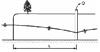
Transient stream depletion
Use MAGNET to perform an evaluation of the following situation:
A well located 5000 ft from a stream which is connected to the aquifer discharges 500 gpm. The transmissivity of the aquifer is 105 ft2t/day, and the specific yield is 0.25. If pumping from the well is to be regulated so that the rate of withdrawal from the stream is less than 50% of the well discharge, how long may the well be pumped?
(Numerical Flow Modeling II - Unsteady- 22),(Stream Depletion - 8)
|
|
|
|
Well interference Dispute III
A dispute has arisen between two farmers after one of the farmers installed a 500 gpm irrigation well 2000 ft. from the small domestic water supply well of the other farmer. After the irrigation well had been operating for 3 months it was observed that the water level in the domestic well had declined over 30 feet. Determine whether it is possible for the water level decline in the domestic well to be produced by pumping from the irrigation well.
(Well Hydraulics - 14),(Numerical Flow Modeling II - Unsteady- 22),(Science in the Court Room- 14)
|
|
|
|
Artificial Recharge Using Spreading Basins
Artificial recharge of groundwater can often take place in spreading basins or stream channels. Build a MAGNET model and derive analytical solutions to characterize groundwater conditions and surface water-groundwater fluxes in this type of system.
(Numerical Flow Modeling I - Steady State- 12),(Aquifer Storage & Recovery- 5)
|
|
|
|
Quick Identification of Groundwater-fed Surface Water Bodies
A research team of hydrologists is attempting to understand the role of a series of ponds and bogs on the regional hydrologic water balance. The immediate objective is to assess which surface water bodies are points of recharge and which are points of discharge, and to make calculations of the monthly and annual gains or losses to the groundwater systems. Outline a field measurement program that would satisfy the immediate objectives at one pond.
(Numerical Flow Modeling III- 20)
|
|
|
|
Mapping Groundwater-Dependent-Ecosystems (GDEs)
With increasing groundwater development around the world, a method is required to identify and map groundwater dependent ecosystems (GDEs) across broad landscape scales. Discuss how MAGNET, especially combined with its hierarchical modeling capabilities and the now widely available 1m lidar DEM data, can be used to identify or to guide field inventory of groundwater dependent ecosystems.
(Numerical Flow Modeling III- 20)
|
|
|
|
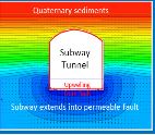
Groundwater Flow into Tunnels
There is probably no engineering project that requires a more compatible marriage between hydrogeology and engineering than the construction of a tunnel.
The prediction of groundwater inflow into a tunnel is important for designing the tunnel drainage system and to minimize environmental impacts and the risk of tunnel instabilities and subsidence damage. Use MAGNET to simulate the groundwater flow into the given tunnel configurations.
(Numerical Flow Modeling III- 20),(Profile Modeling- 6)
|
|
|
|
A Disposal Well
There are more than 680,000 underground waste and injection wells in the US, more than 150,000 of which shoot industrial fluids thousands of feet below the surface. Scientists and federal regulators acknowledge they do not know how many of the sites are leaking. Use MAGNET to investigate the movement of contaminant introduced by a disposal well for specified conditions.
(Numerical Transport Modeling I- 20)
|
|
|
|
Transport of High Level Radioactive Waste
In the case of subsurface disposal of radioactive wastes or highly toxic inorganic or organic compounds, diffusion can be an important process. Consider the following problem: High-level radioactive waste is buried in a cavern in unfractured shale at a depth of 1000 m below ground surface. The burial zone is separated from the nearest overlying aquifer by a vertical thickness of 100 m of shale. Is it reasonable to expect that radionuclides will remain entirely within the shale during the next 100,000 years?
(Numerical Transport Modeling I- 20)
|
|
|
|
|
Continuous source from a polluted ditch, with retardation
An organic contaminant is disposed of continuously in a long narrow trench that fully penetrates a shallow, semi-infinite aquifer. Use MAGNET to simulate the contaminant migration and calculate concentration distribution after three years.
(Numerical Transport Modeling I- 20)
|
|
|
|
Well dynamics - Theis Solution
Theis (1935) presented an exact analytical solution for the transient drawdown in an infinite uniform confined aquifer. Use an analytical approach to calculate the influence of radius for the given parameters. Then develop a MAGNET model to reproduce the Theis solution and to perform sensitivity analysis with respect to aquifer parameters and pumping rate.
(Well Hydraulics - 14),(Numerical Flow Modeling II - Unsteady- 22)
|
|
|
|
Pumping near an impervious boundary
The drawdown due to pumping will be greater near the boundary when a confined aquifer is bounded on one side by a straight-line impermeable boundary. Develop a MAGNET model that can reproduce the analytical solution by applying the model to a specific situation.
(Well Hydraulics - 14),(Numerical Flow Modeling II - Unsteady- 22)
|
|
|
|
Pumping Near a Recharge Boundary
When a Confined aquifer is bounded on one side by a straight constant head boundary, drawdown due to pumping will be less near the boundary.
(Well Hydraulics - 14),(Numerical Flow Modeling II - Unsteady- 22)
|
|

|
|
Transient Aquifer Dynamics In Response To Tidal River Fluctuation
Waves in surface water bodies will propagte into aquifer that are in direct communication with them. Develop a MAGNET model to simulate wave propagation, and compare your results with the analytical solution. Also perform a visual sensitivity analysis of your MAGNET model with respect to storage coefficient, hydraulic conductivity, and frequency of fluctuation.
(Analytical Flow Modeling - Unsteady- 10),(Numerical Flow Modeling II - Unsteady- 22)
|
|
|
|
Unconfined Aquifer - Steady State Flow With Recharge
Consider the head distribution along the length of an unconfined aquifer that is adjacent to two constant head boundaries and receiving constant recharge to the top of the aquifer. Develop a MAGNET model to reproduce the above analytical solution. Further develop the model to simulate vertical flow that is important in the area near the groundwater divide.
(Analytical Flow Modeling - Steady- 12)
|
|
|
|
Confined Aquifer- Steady State Flow With Recharge
Consider the head distribution along the length of an confined aquifer that is adjacent to two constant head boundaries and receiving constant recharge to the top of the aquifer. Develop a MAGNET model to reproduce the above analytical solution.
(Analytical Flow Modeling - Steady- 12)
|
|
|
|
Unconfined Aquifer with Infiltration, calibration
A water supply well at a paper factory is tapping an unconfined aquifer which is exposed to significant infiltration from precipitation. An incomplete record shows a fairly constant drawdown in the well and the two nearby abandoned wells. From the available data find the average pumping rate of the well and the average annual infiltration rate. Solve the following problem analytically and using MAGNET and compare the results.
(Analytical Flow Modeling - Steady- 12)
|
|
|
|
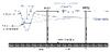
Gradual Linear Change at the Boundary
Simulate an unconfined aquifer under direct influence of a large perennial river. Water table fluctuations are monitored by two wells placed along an average streamline of groundwater flow. The hydrographs show two episodes of a gradual increase in the water table which are consequences of the following:
1) a change in the river stage during a period without precipitation in the study area (first episode), and 2) a change in the river stage accompanied with infiltration from precipitation during a two-week period with frequent rains (second episode). Also perform sensitivity analysis and estimate aquifer properties and the infiltration rate.
(Analytical Flow Modeling - Unsteady- 10),(Numerical Flow Modeling II - Unsteady- 22)
|
|
|
|
Stochastic Geological Modeling Using Transition Probability
A transition probability-based geostatistical approach caled T-PROGS can be used to o analyze spatial variability and generate realizations of geologic units or facies. Importantly, the realizations attempt to honor existing data and display consistency with the spatial variability evident in data or other geologic observations. Watch the videos for some examples of transition probability-based geological modeling using borehole lithologic data. Then use MAGNET to develop a TP-based geological model for a few sites in Michigan.
(Stochastic Flow & Transport Modeling- 15)
|
|
|
|
Realtime Transport Modeling
MAGNET allows a user to initiate particle tracking and/or reactive contaminant transport modeling anytime during the integrated simulation process. Use MAGNET to reproduce and visualize models as demonstrated in the MAGNET Quick Tutorials.
(Data-enabled Modeling Platform- 17)
|
|
|
|
Integrated Visual Simulation and Analysis
MAGNET functions as a “digital groundwater laboratory” in which a user can freely and naturally explore and experiment in real-time: creating visually an aquifer of desired configurations and characteristics, interactively applying desired stresses, and then quickly investigating and visualizing on the fly the geology and the dynamic processes of flow and contaminant transport and transformation. Use MAGNET to reproduce and visualize models as demonstrated in the MAGNET Quick Tutorials.
(Data-enabled Modeling Platform- 17)
|
|
|
|
Realtime Hierarchical Modeling
Utilizing its real-time hierarchical modeling capability, MAGNET allows investigating a complex groundwater system across multiple spatial scales. User can obtain high resolution dynamics in areas of critical interest (e.g., around wells, contamination hotspots) by developing a hierarchy of groundwater models of increasingly higher resolution and smaller domain. Use MAGNET to reproduce a multi-scale model as demonstrated in the MAGNET Quick Tutorial.
(Data-enabled Modeling Platform- 17)
|
|
|
|
Integrated, Dynamic 3D Visualization
MAGNET allows a user to graphically present any combination of model inputs and/outputs for graphic display; to compute and graphically display solute mass, water fluxes and/or water budgets over any specified zones or along any specified "compliance surfaces"; and to compute and graphically display heads and contaminant concentrations as a function of time at a monitoring well. Study the Detailed Tutorial on realtime modeling and visualization under MANUALs on the MAGNET website.
B - Develop a MAGNET model that reproduces the simulation as depicted in the tutorial
C - Perform sensitivity analysis of your model with respect to different display settings. For example,
(Data-enabled Modeling Platform- 17)
|
|

|
|
Groundwater Contamination - Variability & Natural Sources
Given its importance as a supply of freshwater needed to support society, the quality of groundwater is of paramount importance. Groundwater may not be suitable for use because it contains dissolved inorganic substances coming from natural sources (e.g., chloride, sulfate, etc.) or organic liquids, dissolved organic/inorganic constituents, or pathogens from anthropogenic sources. The purpose of this exercise is to explore variabilities in groundwater contamination that make management a challenge.
(Global Water Issues- 9)
|
|
|
|
Groundwater Contamination - Agricultural & Nitrate
Nitrate has emerged as one of the most alarming and widespread contaminant of groundwater and surface water resources reported around the globe. Nitrate formation is an integral part of nitrogen cycle and is added either by the natural processes (atmospheric fixation, lightning storms) or through anthropogenic activities (fertilizer applications, septic tanks). Nitrate enters the hydrosphere easily, and its ingestion causes various health risks such as methemoglobinemia, cancer, diabetes, etc. on humans and to some extent on livestock populations as well. Agricultural practices and subsequent fertilizer application along with other anthropogenic activities are assumed to be the primary reason behind elevated levels of nitrate in groundwater.
(Global Water Issues- 9)
|
|
|
|
Groundwater Contamination - Emerging Contaminants & PFAS
PFAS, also known as highly fluorinated chemicals, are a group of man-made substances used in products ranging from firefighting foam to microwavable popcorn packaging. When released into the environment, PFAS can travel far from their source, which heightens the chance of human exposure through drinking water or food. An analysis by the Environmental Working Group has shown that nearly 100 million Americans may have PFAS in their water.
(Global Water Issues- 9)
|
|
|
|
Numerical Modeling of Artificial Recharge Mound Underneath a Recharge Basin
Artificial recharge of groundwater can often take place in spreading basins or stream channels. Build a MAGNET model and derive analytical solutions to characterize groundwater conditions and surface water-groundwater fluxes in this type of system.
(Numerical Flow Modeling II - Unsteady- 22),(Aquifer Storage & Recovery- 5)
|
|

|
|
Land Subsidence and Sinking Cities
Subsidence is a global problem and, in the United States, more than 17,000 square miles in 45 States, an area roughly the size of New Hampshire and Vermont combined, have been directly affected by subsidence. Land subsidence is most often caused by human activities, mainly from the removal of subsurface water. Other things that can cause land subsidence: aquifer-system compaction, drainage of organic soils, underground mining, hydrocompaction, natural compaction, sinkholes, and thawing permafrost.
(Global Water Issues- 9)
|
|
|
|
Groundwater Depletion
In the drier areas of the world where surface water is scarce, groundwater is abstracted in large volumes in order to irrigate crops, and to a lesser extent for drinking water supply and industry. If groundwater abstraction exceeds groundwater recharge for extensive areas and long time, overexploitation or persistent groundwater depletion can occur. The resulting lowering of groundwater levels can have devastating effects on natural streamflow, groundwater fed wetlands and related ecosystems.
(Global Water Issues- 9)
|
|

|
|
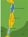
Biscayne Aquifer
The Biscayne aquifer is one of the most permeable aquifers in the world and consists principally of two layers: the Miami Limestone formation and the Fort Thomson formation. Calculate the shape of the phreatic surface and the flow between two fully penetrating canals 1 km apart using: MAGNET-IGW; MAGNET-MODFLOW; and an analytical approach. Compare the results and explain any differences.
(Numerical Flow Modeling I - Steady State- 12)
|
|

|
|
A Municipal Well Field
A municipal wellfield consists of five water supply wells. The wells are located 100 m apart along a north-south line and fully penetrate a 20-m thick confined aquifer. Estimate the drawdown 500 m west of the center well after one week, one month, one year, and one decade of wellfield operation. Solve the problem using MAGNET and an analytical approach.
(Numerical Flow Modeling II - Unsteady- 22)
|
|

|
|
Artificial recharge through wells
Artificial recharge is possible through injection wells after rainfall events for groundwater storage and recovery purposes. Use MAGNET to assess the effectiveness of an example Aquifer Storage and Recovery (ASR) project. In particular, simulate and compare the aquifer drawdown in the dry season i) with artificial well injection during the wet season; and ii) without artificial well injection during the wet season.
(Analytical Flow Modeling - Unsteady- 10),(Numerical Flow Modeling II - Unsteady- 22),(Aquifer Storage & Recovery- 5)
|
|
|
|
Capping of a Landfill
Water levels in the St. Johns landfill is well above the water level in the surrounding surface water bodies due to infiltration of precipitation. This provides a driving force for leachate loading into the surface waters as well as the deep aquifer below the landfill. Metro recently capped the landfill to prevent further infiltration of precipitation. You are asked to evaluate to evaluate the effectiveness of landfill capping by developing an analysis which describes the dissipation of the leachate mound inside the landfill
(Lumped Parameter Models- 8)
|
|

|
|
Containment of a Contaminated Site using a Slurry Wall
A contaminated waste disposal site is contained by constructing a slurry wall keyed into an aquitard. A contaminated waste disposal site is contained by constructing a slurry wall keyed into an aquitard as shown below. The contained area is roughly circular with radius R and is covered with a clay cap which prevents infiltration of precipitation. For the given parameters, find: (1) the steady-state water level inside the wall; (2) the total steady flow leaking through the slurry wall; and (3) the time required for the average concentration of a nonreactive solute inside the contained area to be reduced to 5% of its original value.
(Lumped Parameter Models- 8)
|
|
|
|
Well Water Contamination Dispute
Trouble is a brewin' in the valley. Lil' Pete is darn tooting mad 'cause he thinks his well water is being contaminated by Phil's-not-so-fabulous pigs. He is getting ready to sue Phil to cover the losses he faced on last year's bumper crop of mutant tomatoes and he wants to get the facts right before he hires Johnnie Cochran and turns this thing into a national scandal. He hires you to model the groundwater hydrology of the basin to corroborate his theory.
(Featured Active Learning Projects- 24)
|
|
|
|
Well Interference Dispute I
Farmer Buck wants to install a new pump to aid in the irrigation of his crop of… (well, we couldn't tell you that or Farmer Buck would be in a lot of trouble!). Buck's neighbor Willie doesn't want the new well to interfere with his own well's production. Willie has said that he doesn't care how much Buck pumps as long it doesn't draw down the existing well by more than 0.5m. It is up to you to maximize Buck's pumping rate without making Willie go dry.
(Featured Active Learning Projects- 24)
|
|

|
|
What lies underneath?
Create a hydrogeologically meaningful MAGNET model that can produces observed flow patterns.
(Flow Net & Refraction- 7)
|
|

|
|
Flow Net Analysis - II
You are interested in recharge, residence time and flow velocities in the regional confined aquifer. Using the given information and making reasonable (but only necessary) assumptions regarding aquifer properties, quantify these parameters of interest. Solve the problem 'by hand', then use MAGNET to verify/compare your results.
(Flow Net & Refraction- 7)
|
|

|
|
Investigation of an Aquifer System
Find (in books or journals, or online) an aquifer system and describe its main characteristics. Look at the aquifer type, size, location, its geology, the source of water, its relation to other aquifer and surface water bodies, how the aquifer is used, how water levels (piezometric heads) changed in time, etc. Use less than 500 words (one page) of text.
(Aquifers & Geology- 16)
|
|
icon1.jpg)
|
|
Effective Stress, Porosity, Compressibility, and Compaction
Subsidence is a global problem and, in the United States, more than 17,000 square miles in 45 States, an area roughly the size of New Hampshire and Vermont combined, have been directly affected by subsidence. Analyzing subsidence for the a specific situation.
(Aquifer Properties & Heterogeneities- 14)
|
|

|
|
Flow net analysis 1
Consider an aquifer near a stream and with a pumping well. Use the completed flow net to determine fluxes and source water areas to/for the water well and stream. Also determine contaminant transport paths and travel times. Develop and apply a MAGNET model to verify your results.
(Flow Net & Refraction- 7)
|
|
|
|
Contaminant Transport in Stochastically Stratified Media
This problem considers the movement of a benzene plume in a stochastically stratified confined aquifer toward a lake used for recreation and drinking water supply. Using MAGNET, asses the risk, or probability of the contaminant concentration exceeding the MCL at the aquifer-lake interface.
(Darcys Law & Effective Conductivities - 13),(Stochastic Flow & Transport Modeling- 15)
|
|
|
|
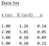
Statistical analysis of K and n data
Perform a statistical analysis for a core of aquifer material, sectioned and tested on a permeameter. Consider frequency distributions, autocorrelations, and crosscorrelations.
(Aquifer Properties & Heterogeneities- 14),(Stochastic Flow & Transport Modeling- 15)
|
|
|
|
Drinking Water, Food Safety, and Arsenic Groundwater Contamination
Groundwater withdrawals have increased significantly in developing parts of the world to support growing populations and increased domestic food production. But in some of these areas, the groundwater is dangerously contaminated with heavy metals like arsenic, raising concerns over the safety of the food and water being consumed by the population. Investigate a site in the Munshiganj district in Bangladesh and analyze impact of drinking water wells and irrigation wells with respect to the groundwater-surface water interactions that drive the arsenic groundwater contamination problem.
(Numerical Flow Modeling III- 20),(Featured Active Learning Projects- 24)
|
|
|
|
An “Odd” Phenomenon
Zeke, the well driller with a healthy curiosity, has a question for you. He had installed a set of wells in an aquifer he knows (accurately) to be confined. One of the wells was turned on and pumped continuously. Head measurements were taken at the surrounding wells. Playing around with Darcy’s law, he noticed an “odd” phenomenon: based on his calculations from the heads of surrounding wells, the amount of water flowing toward the well appeared to increase over time. Yet the pumping rate at the well was constant. Explain to the well-driller what was happening.
(Aquifer Properties & Heterogeneities- 14)
|
|
|
|
Agricultural Drains
Drains are sometimes used in agricultural regions with high water tables. Drains are thought to create a healthier environment for plant growth and to dry the soil so that it can be accessed by farm equipment throughout the crop production cycle. Build a MAGNET model to simulate the lowering of the water table at a farm as a result of two parallel agricultural drains constructed as trenches. Also solve the problem analytically and compare the results from the two different approaches.
(Numerical Flow Modeling I - Steady State- 12)
|
|

|
|
Flow through an Embankment
Flow passes through a stratified embankment from a lake on the upstream side to a lower water level on the downstream side. Develop a three layer MAGNET model and find the flow into the lower reservoir through the embankment and the distance from the upstream end at which layer 3 becomes unsaturated. Also solve the problem analytically and compare the results, and explain the difference, if any.
(Numerical Flow Modeling I - Steady State- 12)
|
|

|
|
Well Placement and Water Quality
A river has a total dissolved solids (TDS) concentration that averages Cr = 1200 mg/l, while groundwater recharging the river has a TDS concentration Cg = 300 mg/l. We want to place a water well which will produce 20,000 cubic feet per day (100 gpm) as close to the river as possible and still meet a water quality limit of c = 500 mg/l TDS. Use MAGNET to simulate the groundwater flow and the water quality dynamics in the mixing zone and use the result to identify the optimal well location.
(Numerical Transport Modeling I- 20)
|
|
|
|
Contaminant Influx from a Pulse Release
A recharge well receives a conservative contaminant in the effluent from a treatment plant. Recharge from the well is captured by a river located 500 m downgradient through an aquifer. Use MAGNET to determine the contaminant influx (loading) to the river as a function of time. In particular, determine the maximum influx.
(Numerical Transport Modeling I- 20)
|
|

|
|
Landfill and a Compliance Monitoring Well
An industrial facility has a 2 acre on-site landfill for disposal of solid waste. A thick, sandy aquifer lies beneath the facility. A regulatory compliance well is located on the site boundary. Using the provided site information, develop a MAGNET model to determine maximum landfill leachate concentration for a conservative species, and for a species with a retardation factor of 2 and a hydrolysis half life of 600 days.
(Numerical Transport Modeling I- 20)
|
|
|
|
Accidental Spill from Truck Hauling Liquid Waste
A truck hauling liquid waste has overturned on the highway. The waste is not recovered at the time of the spill, and we are interested in the concentration reaching a small stream located at a distance 150 meters from the highway and running parallel with it. Use MAGNET to determine the maximum concentration of waste reaching the stream, and plot the stream concentration that will be observed by downstream users of surface water from the stream.
(Numerical Transport Modeling I- 20)
|
|
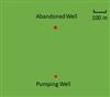
|
|
Abandoned Well and Ilegal Dumping
An abandoned well located 400 m from a municipal water well was used by miss Magda of the Devil's Grail Enterprises, Inc. as an illegal hazardous waste disposal site. Map the drawdown distribution around the pumping well and determine the travel time from the abandoned well to the pumping well. Also, it was recommended that the municipal well should become an injection well. After some time, the contaminant would flow back to the abandoned well, where it would be neutralized. Will the plan work? Why or why not?
(Numerical Transport Modeling I- 20)
|
|
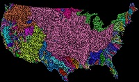
|
|
Big Data Controlling Natural, Prevailing Groundwater Patterns
Ongoing advancements in geospatial data collection has drastically increased the amount of hydrologic/environmental data available. Parallel development of Geographic Information Systems (GIS) and web-based data acquisition from big data repositories provides modelers with an unprecedented opportunity to integrate data collected from various sources (e.g., traditional hydrogeological field studies, remote sensing products, etc.) within a common spatial framework. se MAGNET to explore and experiment. For a specific watershed, or site determine what is the most important dataset that controls prevailing patterns of natural groundwater systems.
(Data Needs and Big Data- 2)
|
|
|
|
Groundwater Contamination at Dry Cleaners
Dry cleaner establishments are quite common in urban settings. And so is the contamination that is associated with dry cleaning activities. Such contamination may pose serious health risks due to its nature and resistance to environmental degradation. Use MAGNET to simulate the migration of two TCE contamination plumes at a dry cleaner site.
(Numerical Transport Modeling I- 20)
|
|

|
|
Recharge Mound Growth/Decay Dynamics
When natural percolation of precipitation is insufficient to replenish groundwater withdrawn for human use, artificial recharge helps prevent aquifer depletion, subsidence and saltwater intrusion. Determine the rise in the mound below the center of a recharge basin after 15 days from the instant the infiltrated water reached the water table. If the infiltration stopped after 15 days, determine the decay in the groundwater mound 6 days later. Solve the problem using MAGNET and an analytical approach.
(Numerical Flow Modeling II - Unsteady- 22)
|
|
|
|
PFAS Impact Area Analysis
John and Jane operate a successful, luxurious resort, but their groundwater supply is threatened by a major underground toxic PFAS plume found upstream of their community well. Initially, they were told the plume is outside of the 10-year “wellhead protection area”, or area of contribution. But now they aren't so sure as more data about the complex subsurface has become available. You be the judge...what is the risk to John and Jane's business?
(Science in the Court Room- 14),(Featured Active Learning Projects- 24)
|
|
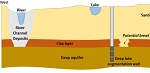
|
|
Lake Augmentation Controversy - Old
Home owners from a beautiful lake community faced a water problem: their lake was ‘sick’ – it was losing water and lake levels were getting lower. An expert "fixed" the problem by pumping deep groundwater directly into the lake. But years layer, the same problems returned. A second expert says the plan never really worked in the first place. Determine if the lake augmentation project was doomed from the beginning.
(Science in the Court Room- 14)
|
|
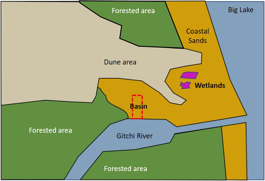
|
|
Dewatering Controversey
Big Dune Shores LLC is proposing to construct a 17 ft deep boat marina near Big Lake at the mouth of the Gitchi River. But they are running into fierce opposition from the local community and environmental activists who argue that the excavation of the new marina will cause the surrounding water table to decline, including in the area of several important interdunal wetland ecosystems. Dune Shores thinks that a sealed marina bottom will eliminate any long-term impact on the water table in the wetland areas, and a quick dewatering operation will result in a temporary drawdown of the water table that is well within natural fluctuations. You be the judge … would the proposed plan by the developer work? Should permits be issued for construction?
(Science in the Court Room- 14),(Featured Active Learning Projects- 24)
|
|
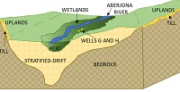
|
|
A Civil Action - the Woburn Trial (Basic Version)
In 1972 in the town of Woburn, Massachusetts, families of 13 different children who had contracted a rare form of childhood leukemia sued two large companies for the contamination of their community water supply wells. But the companies denied any responsibility, arguing that water originating from their plants may never be able to reach the community wells given the local hydrogeologic conditions. Instead, the companies blamed the heavily polluted Aberjona River as the source of contamination to the wells, given it's very close proximity to the community wells. You be the judge... who is responsible?!? Revisit the famous trial as modern-day ‘expert consultants’, addressing the debate issues based on the interpretation of groundwater flow and contaminant transport simulations. (PURELY FORWARD MODELING - NO CALBRATION)
(Science in the Court Room- 14),(Featured Active Learning Projects- 24)
|
|
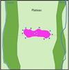
|
|
Groundwater Cleanup System Analysis & Design
Cleanup Guru LLC won a major contract award to cleanup a groundwater contamination site – one of the largest under active remediation in the state. The project, however, did not go particularly well. In fact, the site owners who funded the contract accused the company of malpractice, arguing that the project which aimed to contain the plume actually accelerated the offsite migration to the creeks and to the wetlands and to the lakes downstream. Perform an independent assessment of the cleanup system and develop a new capture system that can contain the groundwater contamination.
(Featured Active Learning Projects- 24)
|
|
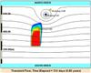
|
|
Continuous Surface Source of Contamination
Surface water migrates into the groundwater by infiltration through the soil, or by runoff into areas where the water table is above the surface of the ground. Develop a MAGNET model representing a contamination plume originating from surface contamination zone represented in three different ways: "prescribed flux" with a specified concentration, representing a leaky waste water pond above the water table; "two way head dependent flux" with specified concentration, representing a polluted pond that is hydraulic connected with the aquifer; and
"prescribed head", with a specified concentration, representing a polluted pond fully connected with the aquifer.
(Numerical Transport Modeling I- 20)
|
|

|
|
'Quick and Dirty' Data-Enabled Model
MAGNET allows users to almost instantly create a data-enabled simulation of natural groundwater conditions in the near-surface aquifer (i.e., the unconfined, water table aquifer) critical for water resource development and sustaining of groundwater-dependent ecosystems. This "Quick and Dirty" model is not meant to be complete, but rather serve as a framework for customization – it is a preliminary, default model that can be modified, extended, and further customized based on study objectives and other available (local) data, as well as user experience and expertise. Use MAGNET to reproduce a Quick and Dirty data-enabled model as demonstrated in a MAGNET Quick Tutorial.
(Data-enabled Modeling Platform- 17)
|
|
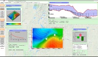
|
|
Realtime Unsteady Flow Modeling
MAGNET enables the modeler to produce sophisticated 2D and 3D graphical displays of spatial, time-varying information at any point during the modeling process. Being able to visualize the model system's behavior at every time step and evaluate its adequacy is a powerful tool, so that you can interrupt the computations, alter the model in significant ways, and restart computations as you deem necessary. Use MAGNET to reproduce a realtime unsteady flow simulation as demonstrated in the MAGNET Quick Tutorial.
(Data-enabled Modeling Platform- 17)
|
|
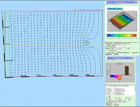
|
|
MAGNET Synthetic Models
Sometimes it is necessary to create a model that is not tied to any particular real-world location. Instead, we may need to create a model that represents an idealized or purely hypothetical situation. These "synthetic" models are very useful for understanding groundwater processes and testing proposed methods in groundwater modeling, because all aspects of model construction and parameterization are known (which is never the case when modeling real-world sites.). Learn how to build synthetic models in MAGNET by reproducing the model presented in a MAGNET Quick Tutorial.
(Data-enabled Modeling Platform- 17)
|
|
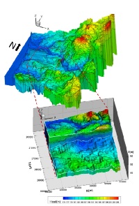
|
|
3D Groundwater Models
There are instances when we are interested in groundwater conditions in different geological layers (sometimes called hydrostratigraphic units, aquifer layers, or conceptual layers) - or how a leaky confining layer impacts groundwater conditions in an adjacent aquifer layer. Such cases requires a 3D model with two or more aquifer layers. Other times, we may need to resolve vertical processes within one or more aquifer layers. Use MAGNET to reproduce 3D models of both types as demonstrated in the MAGNET Quick Tutorial and the Woburn Superfund Site problem.
(Data-enabled Modeling Platform- 17)
|
|
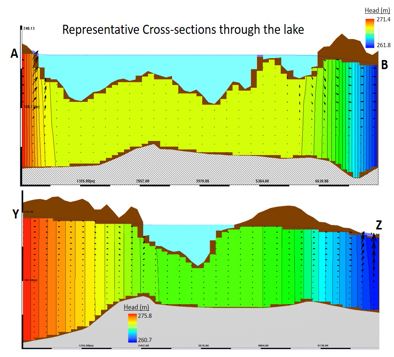
|
|
Vertical Profile Models
It is sometimes necessary or insightful to develop two-dimensional flow models in the vertical plane. These types of models are called often called vertical cross-section or vertical profile models. MAGNET offers two quick and easy ways to build a vertical profile model: 1) When the water table is known or prescribed, the y-coordinate can be treated as the vertical dimension; and 2) when the water table is not known ahead of time, a "slice" or cross-section of a 3D model can be analyzed and visualized. Create a synthetic example using both approaches, and discuss the relative advantages and disadvantages of the two different approaches.
(Data-enabled Modeling Platform- 17)
|
|
|
|
|
Realtime Model Evaluation & Calibration
For many real-world modeling applications, it is necessary to evaluate the model performance by comparing simulated outputs (e.g., heads) to measured field parameters (e.g., water levels in monitoring wells). MAGNET allows almost instant comparison of simulated heads with observed groundwater levels available across the model domain (steady-state, single time-step, or temporally-aggregated) or at discrete locations for all time-steps (time-series comparisons). Use MAGNET to reproduce the calibration exercises as demonstrated in the MAGNET Quick Tutorial.
(Data-enabled Modeling Platform- 17)
|
|
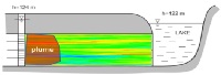
|
|
Contaminant Transport in an Aquifer - Homogeneous vs. Stratified
This problem considers the movement of a benzene plume in a confined aquifer toward a lake used for recreation and drinking water supply. Using MAGNET, asses the risk, or probability of the contaminant concentration exceeding the MCL at the aquifer-lake interface. Analyze and compare the following situations i) a homogeneous aquifer; ii) a stratified aquifer; and iii) a stochastically stratified aquifer.
(Numerical Transport Modeling I- 20),(Darcys Law & Effective Conductivities - 13),(Analytical Fate & Transport Modeling- 1),(Stochastic Flow & Transport Modeling- 15)
|
|
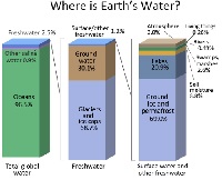
|
|
Groundwater Use & Availability
How much fresh groundwater is available for use by society? How does this availability vary across the globe or at different times? What controls the availability/variability? Develop your own answers to these questions through this reading lesson! A few short questions are included to stimulate critical thinking.
(Hydrological Cycle - 6)
|
|
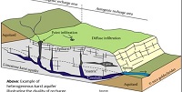
|
|
Principal Aquifers by Rock Type – Carbonate Rocks
Rocks that are primarily composed of calcium carbonate constitute about 20 percent of the earth’s sedimentary rocks and they underlie about 40 percent of the land surface in the United States. These carbonate rocks consist of limestone and dolomite that contain groundwater in fractures and pore space which, in the year 2000, provided water at a rate of 5,840 million gallons per day from 16 principal carbonate-rock aquifers in the U.S. (Maupin and Barber, 2005). Despite their importance for water supply, many aspects of groundwater flow in carbonate aquifers are poorly understood.
(Aquifers & Geology- 16)
|
|

|
|
Principal Aquifers by Type - Unconsolidated Aquifers
Erosion and deposition are two earth processes that shape much of the surface and near surface of the Earth. Much of the Earth’s near-surface material consists of geologically recent deposits that are unconsolidated (loosely arranged or consisting of particles are not cemented together). Coarsely grained near-surface deposits are among the most important aquifers because they are an active part of the water cycle and because they generally yield water more readily than their consolidated equivalents. Most unconsolidated aquifers are composed of sand and gravel that was carried by water either in streams flowing from runoff or from melting ice, especially over the last three million years during continental glaciation. Learn more in this guided lesson with short-answer Discussion Questions.
(Aquifers & Geology- 16)
|
|
|
|
|
A Civil Action - the Woburn Trial (Advanced Version)
In 1972 in the town of Woburn, Massachusetts, families of 13 different children who had contracted a rare form of childhood leukemia sued two large companies for the contamination of their community water supply wells. But the companies denied any responsibility, arguing that water originating from their plants may never be able to reach the community wells given the local hydrogeologic conditions. Instead, the companies blamed the heavily polluted Aberjona River as the source of contamination to the wells, given it's very close proximity to the community wells. You be the judge... who is responsible?!? Revisit the famous trial as modern-day ‘expert consultants’, addressing the debate issues based on the interpretation of groundwater flow and contaminant transport simulations. (INVOLVES MODEL CALIBRATION)
(Featured Active Learning Projects- 24)
|
|
|
|
Principal Aquifers by Rock Types - Igneous and Metamorphic Rocks
Igneous and metamorphic rocks seem unlikely candidates for storing and moving water, and, from a primary porosity and permeability perspective, little groundwater moves in these rock types. There are, however, other factors (e.g., depositional modes) that complicate the general perception that these rock types are improbable aquifers. Learn more in this engaging reading lesson and answer the short Discussion Questions to stimulate critical thinking.
(Aquifers & Geology- 16)
|
|
|
|
The Importance of Groundwater in the North American Great Lakes Region
The North American Great Lakes constitute about 20 percent of the Earth’s unfrozen fresh surface water. Because the amount of surface water in the Great Lakes is so large, groundwater in the Great Lakes Basin is often overlooked when evaluating the hydrology of the region. It is, however, more significant than is generally recognized (Grannemann and others, 2000). This lesson is designed to illustrate how groundwater and surface water interact in this water-rich region and can be used as a guide to understanding the complexity of this interaction in other similar regions.
(Regional Spotlights- 1)
|
|
|
|
Missouri River Alluvial Groundwater Problem
This lesson uses information from the Missouri River alluvial valley on the lower reaches of the River and groundwater modeling to explore in more detail how water flowing in one of the world’s largest rivers interacts with its adjacent groundwater.
(Surface & Ground Water Interaction- 8)
|
|

|
|
Water Withdrawal Controversy
Prairie Valley Water is installing a high-capacity well to support their expanded bottled water operations. But the company's permit is denied by the state because the state’s water withdrawal assessment tool predicted that their proposed well could adversely impact the nearby trout stream. The company argues that their well will pump deep groundwater which will have no impact on what happens at the surface. You be the judge…should Prairie Valley Water get a permit?
(Featured Active Learning Projects- 24)
|
|
|
|
Drinking Water Contamination Dispute
Homeowners in a small community filed a lawsuit against a nearby food processing plant for the contamination of their water wells with heavy metals. They claimed that the source of the problem is the food processing company’s spray irrigation of its waste water at four large fields in the vicinity. But the food processing company denied the charges, arguing that they never used any chemicals involving heavy metals in their operations and even if the water from the spray irrigation is a problem, it cannot possibly reach most of the water wells because they are outside the impact area of the spray irrigation. You be the judge… is the company responsible?!?
(Featured Active Learning Projects- 24)
|
|
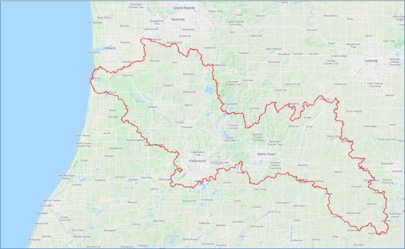
|
|
Modeling Groundwater Flow in the Kalamazoo Watershed
The Kalamazoo River watershed is known for its richness in biodiversity, ecosystem services and recreational opportunities, as it consists of many lakes, headwater streams, wetlands, and flood plains which benefit from substantial groundwater contributions.
However, there is growing pressure from development, urbanization, and agricultural operations that extract groundwater in the watershed as their water supply. You are to develop a groundwater flow model of the Kalamazoo watershed using MAGNET to characterize the system dynamics (flow patterns and interactions with surface water bodies), evaluate data worth, and identify management implications - taking advantage of pre-processed BIG DATA to represent the spatial hydrogeologic framework network and parameterize groundwater-surface water interactions.
(Data Needs and Big Data- 2)
|
|
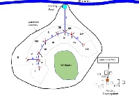
|
|
Storm Water Management Project
You have been hired by a developer to help with the design of a major development complex. The proposed development site, which totals 73.3 acres, sits within a small catchment with a creek that drains into an ecologically important stream at the outlet of the catchment. There is also an existing housing development southeast of proposed development. Because of the water-quality limited designation of the stream, the developer needs to design a storm water system that will minimize the impact on it. One approach is to collect and route stormwater to wetlands adjacent to the development site for natural infiltration into the groundwater system. Another idea is to route storm water through a storm-sewer network and a holding pond to attenuate the flow into the stream and allow for settling of large particulates. Your objective is to determine the feasibility of the two approaches, given the constraints related to streamflow and water table in the area of the existing development.
NOTE: Part 2 can be done independently for courses only interested in performing a groundwater modeling exercise. Contact support@magnet4water.com for additional assistance.
(Featured Active Learning Projects- 24)
|
|

|
|
Introduction to Groundwater - Multiple Short Exercises
An introductory lesson consisting of 5 short exercises for students to complete. Ideal for the beginning of a course on groundwater hydrology (or general hydrology, too). Instructors can assign all of the exercises or a sub-set. Solutions and student sample reports can be made available to instructors upon request: support@magnet4water.com
|
|
|
|
|
MAGNET for Beginners
This exercise asks students to read the MAGNET users manual prepared especially for beginners and students, and to submit a set of key screen shots summarizing their work, including images of your modeling result on regional groundwater flow pattern, local groundwater flow pattern, particle tracking (forward/backward), and contaminant plume migration (in plan view and cross-sections).
|
|
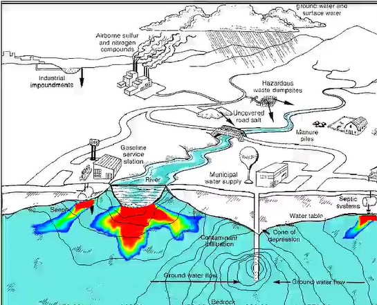
|
|
Introduction to Fluid Mechanics
This introductory lesson touches on experimental, analytical, and computational approaches in the study of fluids. A short series of exercises help to develop a sense of the different approaches and their relative strengths and limitations.
(Featured Active Learning Projects- 24)
|
|
|
|
|
Lake Augmentation Controversy
Home owners from a beautiful lake community faced a water problem: their lake was ‘sick’ – it was losing water and lake levels were getting lower. An expert "fixed" the problem by pumping deep groundwater directly into the lake. But years layer, the same problems returned. A second expert says the plan never really worked in the first place. Determine if the lake augmentation project was doomed from the beginning.
(Featured Active Learning Projects- 24)
|
|
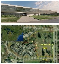
|
|
Stormwater System Design Project 1
You are hired to analyze (and improve upon) a preliminary design for a stormwater management system for the proposed Tech Smith headquarters to be located on the Michigan State University campus in East Lansing, Michigan . Stormwater captured by buildings, sidewalks and other paved areas is to be conveyed to an on-site holding pond through a proposed system of junctions (manholes) and conduits (pipes). Using both spreadsheet approaches and a sophisticated simulation software – MAGNET StormNET - you will design (and then refine) the pipes (including their sizes, slopes, and roughness) and a holding pond (total volume, dimensions, and outflow control structures). You will also assess potential impact of Low Impact Development (LID) controls or other green infrastructure integrated into the system.
(Featured Active Learning Projects- 24)
|
|
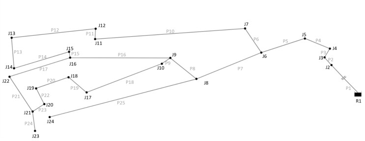
|
|
Drinking Water Distribution System Design 1
A small (but quickly growing community) relies on groundwater to meet its water needs. But over pumping of the aquifer is causing deeper, highly mineralized groundwater to migrate to the shallow subsurface, contaminating the local supply. The community has decided to switch to surface water supply and needs to build a drinking water distribution system that must satisfy certain requirements. The community’s Development Company provided a preliminary design of the distribution system, but the community would like an external review of the design before proceeding with construction. You have been hired analyze the hydraulic feasibility of the preliminary design, particularly with respect to minimum pressure and flow velocity requirements: pressure at all junctions with non-zero demand should exceed the minimum allowable pressure of 15 psi but be less than 165 psi (note: all junctions should have positive pressure). Velocity in the pipes should exceed 1 ft/s but be less than 8 ft/s.
(Featured Active Learning Projects- 24)
|
|
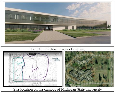
|
|
Stormwater System Design Project 2
Your company has been contracted to design an innovative stormwater management system for the proposed Tech Smith (“Project Hedge”) site, located on the corner of South Harrison Road and Crescent Road within the former Spartan Village development area. The solution must:
• Be aesthetically pleasing and fit into the general landscaping of the MSU campus and the existing stormwater system;
• Incorporate low impact development practices;
• Prevent frequent flooding;
• Prevent further deterioration of the Red Cedar River water quality, including
during storm events;
• Be cost effective;
• Be capable of being permitted from a regulatory standpoint
(Featured Active Learning Projects- 24)
|
|
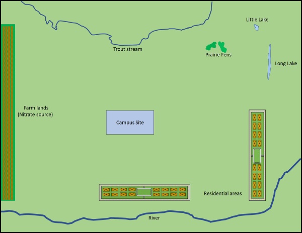
|
|
System-based Water Supply Feasibility Analysis and Design (NEW version!)
A university is planning to build an extension campus near a city, but there may be a "drinking water supply issue" - the large river in the area freezes over in the winter, and the groundwater availability in the in the area is constrained by existing users, ecological constraints, and potential contamination sources. Use a system-based approach to design and analyze a water supply system for the new campus.
(Featured Active Learning Projects- 24)
|
|
|
|