The SwaNET interface is validated against the standard SWAT preprocessing workflow.
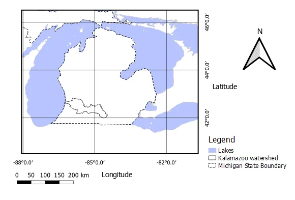
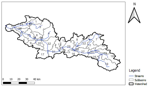
SwaNET was compared directly with QSWAT/SWAT Editor on the Kalamazoo River watershed. The cross-check covered the complete preprocessing chain: DEM-based watershed delineation, subbasin properties, HRU creation, SWAT input behavior, watershed outputs, outlet flow, sediment, nutrients, reach routing, and subbasin water balance.
The practical conclusion is clear: when configured with equivalent data and modeling choices, SwaNET converts the user’s conceptual watershed setup into SWAT input files that reproduce QSWAT/SWAT Editor results for the tested workflows.
QSWAT is the benchmark workflow. SwaNET is the automated interface.
SWAT remains the governing hydrologic and water-quality engine. The validation question is not whether SwaNET replaces SWAT physics; it is whether SwaNET’s web interface, data linkage, delineation workflow, HRU construction, and input-file generation correctly produce SWAT-ready models equivalent to the established QSWAT/SWAT Editor path.
Same governing model
Both workflows create and run SWAT models. This isolates the interface and preprocessing chain rather than comparing different hydrologic solvers.
Same watershed setup
The comparison used the Kalamazoo River watershed, matching DEM source, stream threshold, outlet location, TauDEM process setting, HRU slope bands, and SWAT simulation settings.
Same outputs
The comparison checked not only the final hydrograph, but also the intermediate spatial objects and multiple SWAT output files.
The test constrains the inputs so the interface conversion can be examined directly.
The study used a 90 m DEM for the Kalamazoo River watershed, a stream threshold of 16,000 DEM cells, matching outlets, two slope bands, equivalent HRU selection methods, no point sources, no reservoirs, and a 1989–1995 SWAT simulation with one warm-up year.
Agreement is systematic across spatial preprocessing, HRUs, and SWAT outputs.
A strong validation claim requires more than one matched time series. The comparison checks whether the interface creates the same model objects and then whether those objects produce the same hydrologic, sediment, nutrient, reach, and subbasin behavior.
| Validation layer | What was compared | Observed result | Interpretation |
|---|---|---|---|
| Watershed delineation | Subbasin count, subbasin areas, boundaries, slopes, elevations, and centroid locations. | Matched | SwaNET’s DEM-to-watershed conversion reproduces the QSWAT delineation under equivalent setup. |
| Potential HRUs | Land-use × soil × slope overlay before final filtering. | 2,939 potential HRUs | SwaNET correctly maps spatial attributes into the same HRU candidate structure. |
| Final HRUs | Multiple HRU selection methods; detailed example using 10% land-use, 20% soil, 20% slope thresholds. | 265 final HRUs | The conceptual HRU selection choices in the interface are translated into SWAT preprocessing logic correctly. |
| Annual basin outputs | Water balance and soil nutrient parameters from output.std. | Matched | Whole-watershed mass-balance behavior is identical after model construction. |
| Monthly basin outputs | Rainfall, snowfall, runoff, water yield, evapotranspiration, and sediment yield. | Matched | Seasonal water and sediment behavior is preserved, not merely annual totals. |
| Outlet outputs | Average daily streamflow, sediment concentration, nitrogen, phosphorus, CBOD, and dissolved oxygen. | Matched | The routed outlet response validates the assembled watershed topology and process parameters. |
| Reach and subbasin outputs | Selected reach 27 and subbasin 32 outputs for water quantity and water quality over six years. | Matched | Agreement holds inside the watershed, not only at the basin outlet. |
The same SWAT model behavior appears at every examined scale.
The comparison demonstrates end-to-end equivalence: from spatial discretization to SWAT input files to simulated water quantity and water quality.
Annual basin water balance
- Precipitation: 819.3 mm in both workflows.
- Surface runoff: 120.37 mm in both workflows.
- Baseflow, shallow aquifer: 153.63 mm in both workflows.
- Total water yield: 287.69 mm in both workflows.
- Evapotranspiration: 514.6 mm in both workflows.
Annual basin soil and nutrient terms
- Sediment loading: 1.32 t/ha in both workflows.
- N fertilizer applied: 49.32 kg/ha in both workflows.
- Nitrogen uptake: 63.80 kg/ha in both workflows.
- Phosphorus uptake: 12.84 kg/ha in both workflows.
- Final mineral P: 1550.66 kg/ha in both workflows.
Outlet streamflow: matched year by year
Average daily streamflow ranged from 38.45 to 54.68 cms, with identical SwaNET and QSWAT values.
Outlet sediment concentration: matched year by year
Average daily sediment concentration ranged from 45.7 to 52.4 mg/L, with identical SwaNET and QSWAT values.
SwaNET is validated as a SWAT preprocessing and interface layer for the tested workflows.
The evidence supports a precise claim: SwaNET correctly converts user-facing watershed concepts—study boundary, DEM-derived drainage structure, outlet selection, land-use/soil/slope HRU construction, HRU filtering, weather-generator setup, and SWAT simulation configuration—into SWAT inputs that reproduce QSWAT/SWAT Editor outputs for the Kalamazoo River validation case.
This is a cross-validation of the interface and preprocessing workflow, not a replacement for field calibration or a proof that every possible SWAT option has been exhausted. The value of the result is nevertheless substantial: the comparison verifies that SwaNET can automate the hard preprocessing path while preserving the numerical behavior of the established SWAT/QSWAT workflow.